
Horsham Transport Improvements Consultation
UPDATE: This engagement exercise ran from 11th November to 22nd December 2025. The County Council is currently reviewing next steps for the scheme following the consultation feedback received. The County Council will publish the results of the consultation when it is possible to communicate these together with the next steps. The original consultation webpage text has been retained below.
Horsham Transport Improvements
We are working to improve the transport network across West Sussex so our community can access the things they need. By making it safer, easier and more convenient to get around, particularly by walking, cycling and using public transport, we can help create more pleasant places in which to live, work and do business.
The West Sussex Transport Plan 2022-2036 (opens in new window) sets out how the county council intends to address a number of challenges, including climate change, congestion, public health and road safety through improvements to the transport network.
Our transport plan identifies highway improvements, including bus priority at junctions and active travel infrastructure (e.g. cycle tracks and crossings) as priorities for investment in Horsham. Improvements are now being developed as part of our Strategic Transport Investment Programme (STIP).
Developing the Proposals
We are now consulting on proposed improvements for two key transport corridors within Horsham:
- Rusper Road between Mowbray (North Horsham development) and Horsham town centre via Kings Road and North Street
- A281 Guildford Road between Broadbridge Heath and Horsham town centre via Bishopric.
The comments we receive will help to develop our designs and enable us to seek future funding opportunities.
Why we need improvements
We want to improve these roads because they are important for accessing education, jobs and services. They also connect the growing communities in Broadbridge Heath and Mowbray (North Horsham development) with Horsham town centre.
These roads are currently used by high volumes of traffic during peak times, resulting in congestion, which also impacts the reliability of bus services. Safety is also a problem, with some junctions having a high number of collisions, some of which have involved pedestrians and cyclists. Facilities for walking and cycling are limited and there is lots of on-road parking that narrows the space for other users, particularly near Littlehaven station.
Initial Engagement
We presented our early ideas for this scheme during an initial engagement phase earlier this year. The feedback we received was encouraging, with 61% of respondents indicating support for the proposals, while 26% of respondents expressed some level of opposition. We have used the valuable feedback to refine and develop proposed designs for the corridors. You can find more information on the initial engagement webpage (opens in a new window). add link once permalink updated.
Our proposals for the North Parade/Wimblehurst Road junction have now been included in our West Parade Improvements, Horsham (opens in a new window) further information about the proposals here can also be found in our FAQ's (opens in new window).
Please refer to the Stage 1 Engagement Report (opens in new window) for more detail.
We would like to hear your views on our proposals we are considering, so please complete our survey at the bottom of this webpage.
The consultation is open until 11:55pm on Monday 22nd December 2025.
Our aims
The proposals are expected to improve travel by walking, cycling and public transport by improving road safety and reducing journey times.
The proposals are intended to keep traffic moving and minimise traffic delays.
The proposals are designed to improve and provide new active travel facilities providing better travel options, making local bus services more reliable and attractive, particularly for shorter journeys.
This could help reduce the volume of short-distance car journeys in the area, if more journeys are made by public transport, cycling and walking.
The Proposals
The types of improvements that we are considering include:
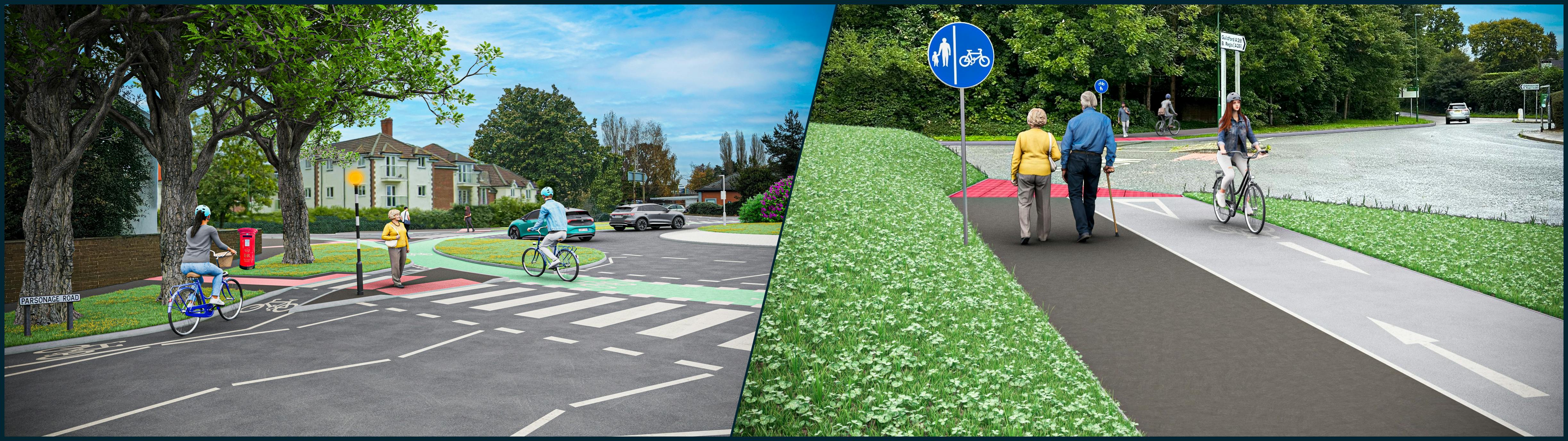
- a 'Dutch' style roundabout at Parsonage Road/Kings Road with segregated cycle track and, parallel pedestrian crossings to give pedestrians and cyclists priority over other vehicles like the example at, Westgate, Chichester (opens in a new window)
- Two-way segregated cycle and pedestrian tracks.
- Sections of shared use (i.e. for walking and cycling) path, and on-road cycle lanes (i.e. advisory and mandatory cycle lanes) where space is limited.
- Raised tables at some side roads near junctions to reduce vehicle speeds.
- New or improved crossings for pedestrians and cyclists.
- Bus priority measures at the Harwood Road/Kings Road roundabout to improve bus journey time reliability.
- Minor junction improvements, such as widening of exit lanes to assist larger vehicles turning.
- Changes to signal timings to minimise delays.
- Banning the right-turn from Station Road onto North Street to prevent delays caused by vehicles turning out of Station Road during peak times.
- Sections of on-street parking restrictions, traffic calming measures, improved directional signage and wayfinding.
Please see the accompanying route maps and scheme descriptions linked below for more information about the proposals.
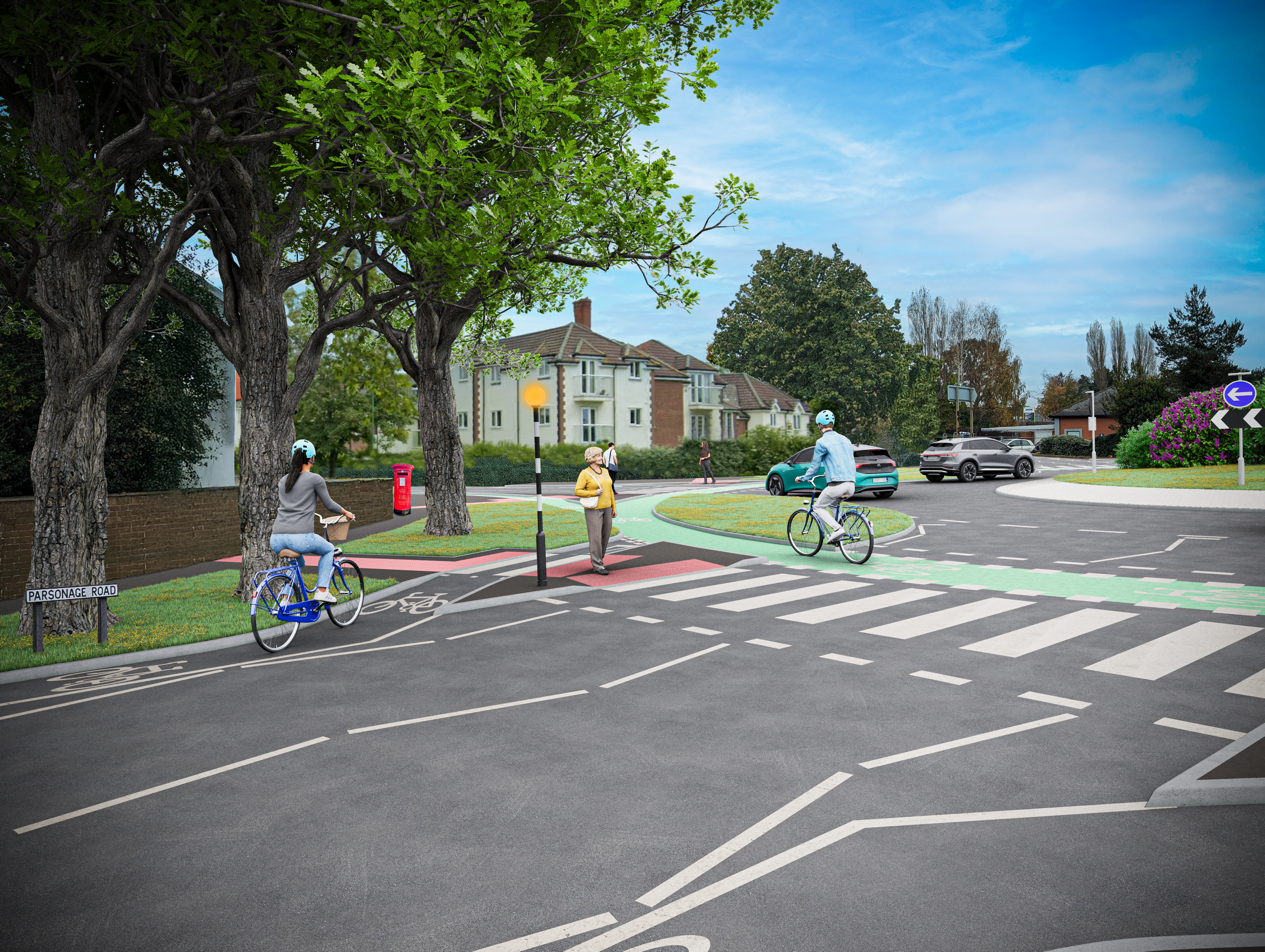
Artists impression of the 'Dutch' style roundabout at Parsonage Road/Kings Road.
- Overview map Rusper Road (opens in a new window)
- Rusper Road between Mowbray (North Horsham development) and Horsham town centre via Kings Road and North Street (opens in a new window)
- Overview map A281 Guildford Road (opens in new window)
- A281 Guildford Road between Broadbridge Heath and Horsham town centre via Bishopric (opens in a new window)
- Scheme description document (opens in a new window)
Funding and Implementation
The scheme is not fully funded at this time, but we are preparing the proposals in readiness for future funding opportunities. The scheme is expected to be funded using developer contributions and central Government grants that can only be used for this purpose. The scheme is at an early stage of development, so it is expected to be several years before construction could commence.
Have your say
We are holding two drop-in events so that you can view our proposals for the scheme and speak to members of the project team:
- Monday 24 November:The Blackridge Community Centre, Three Acres, Horsham, West Sussex, RH12 1RS from 3pm to 7pm
- Parking available on-site
- Tuesday 2 December:Park Barn, North Street, Horsham, RH12 1RJ from 10am to 2pm
- Parking available at North Street, Pay and Display carpark - RH12 9SX
We would like to hear your views on the improvements we are considering by completing our survey (opens in new window) which should only take approximately 10 minutes to complete. The consultation period is open until 11:55pm on Monday 22 December 2025
Alternative formats and accessibility
If you require any of this information in an alternative format, then please contact us via email at LTP@westsussex.gov.uk or by telephone on 01243 642105 and we will do our best to assist you. If you are deaf or hard of hearing and have a BT Relay UK app (opens in new window) (previously known as NGT texting app) installed on your computer, laptop or smartphone, you can contact us on 18001 01243 642105.
For more information about the accessibility of this website, please see our Accessibility tab (opens in new window) at the foot of the page.
Please note, you can use the Google Translate function to access this project in a range of different languages. The Google Translate widget can be found at the top left-hand side of the project page, where it sits just above the black West Sussex County Council ribbon.
Who's Listening


Rusper Road Technical Drawings
-
 Rusper Road Proposals Map 1 of 12 (2.24 MB) (pdf)
-
Rusper Road Proposals Map 2 of 12 (1.99 MB) (pdf)
-
Rusper Road Proposals Map 3 of 12 (1.73 MB) (pdf)
-
Rusper Road Proposals Map 4 of 12 (1.65 MB) (pdf)
-
Foundary Lane-Harwood Road Roundabout Detail Map (758 KB) (pdf)
-
Rusper Road Proposals Map 5 of 12 (1.59 MB) (pdf)
-
Rusper Road Proposals Map 6 of 12 (1.73 MB) (pdf)
-
Kings Road - Parsonage Road Dutch Style Roundabout Detail Map (2.45 MB) (pdf)
-
Rusper Road Proposals Map 7 of 12 (1.96 MB) (pdf)
-
Rusper Road Proposals Map 8 of 12 (1.83 MB) (pdf)
-
Rusper Road Proposals Map 9 of 12 (2.05 MB) (pdf)
-
Rusper Road Proposals Map 10 of 12 (1.76 MB) (pdf)
-
Rusper Road Proposals Map 11 of 12 (2.28 MB) (pdf)
-
Rusper Road Proposals Map 12 of 12 (1.63 MB) (pdf)
Example of 'Dutch' style roundabout, Westgate, Chichester
A281 Guildford Road Technical Drawings
-
A281 Guildford Road Proposals Map 1 of 6 (2.45 MB) (pdf)
-
A281 Guildford Road Proposals Map 2 of 6 (3.01 MB) (pdf)
-
A281 Guildford Road Proposals Map 3 of 6 (2.9 MB) (pdf)
-
A281 Guildford Road Proposals Map 4 of 6 (2.95 MB) (pdf)
-
A281 Guildford Road Proposals Map 5 of 6 (2.89 MB) (pdf)
-
A281 Guildford Road Proposals Map 6 of 6 (1.68 MB) (pdf)