Comptons Lane, Horsham - Walking and Wheeling Improvements.
Comptons Lane, Horsham
Introduction:
West Sussex County Council and Horsham District Council are working together to deliver improvements that will benefit residents, businesses and visitors alike. By encouraging more walking, wheeling and cycling, we can help to reduce congestion on the region’s already busy road network. It will also help to improve air quality and create safer, more pleasant places in which to live, work and do business.
These proposals are focused on improving safety along Comptons Lane, near The Forest Secondary School, to the east of Horsham town centre. The proposals will help people travelling on foot or by bike more easily navigate the area, particularly the high volume of students travelling to and from the school. A key element of the scheme is to reconfigure the junction where Bennetts Road meets Comptons Lane, to improve the layout and ensure the junction can be safely and easily navigated by pedestrians and cyclists. The scheme will help address safety concerns raised by the school and help alleviate congestion along this already busy route.
We are seeking your feedback between Tuesday 23 June 2026 until Tuesday 04 August 2026 to shape further development of our detailed designs and inform our decision on how to take the proposals forward.
Complete the survey here (opens in new window).
About The Proposals:
In 2022 we undertook a public engagement exercise to gather feedback about concept proposals to improve walking, wheeling and cycling to The Forest School. We have used the feedback to develop the scheme and are now seeking your view on our preliminary design proposals.
Located close to The Forest Secondary School, the junction where Bennetts Road meets Comptons Lane, has limited provision for people travelling by bicycle, and can be difficult for pedestrians to navigate. The service road which runs adjacent to Comptons Lane, connects into Bennetts Road in a T-junction arrangement which can create confusion for pedestrians, cyclists and drivers.
The surrounding roads and junctions get congested with traffic, particularly during school pick-up and drop-off times, with increased potential for conflict amongst people travelling on foot, by bike, bus, or in the car. Our proposals in this area aim to improve safety, particularly for the high volume of pupils travelling to and from The Forest School.
Walking, wheeling and cycling improvements:
- Replacing the uncontrolled crossing, near the junction of Bennetts Road with Comptons Lane, with a parallel crossing (opens in a new window) that has dedicated space for pedestrians and cyclists;
- Introducing a new parallel crossing across the main school access;
- Introducing a new parallel crossing across Comptons Lane;
- Introducing a new Zebra crossing (opens in a new window) in proximity to Highlands Road;
- Relocating the current entrance to the service road from Bennetts Road by providing a new entry point for vehicles from Comptons Lane. Access for pedestrians and cyclists from Bennetts Road would be maintained. The service road would stay open to vehicles in both directions, and access to properties maintained. By closing one of the entry points, the proposals would make it safer and easier for those walking, wheeling and cycling to cross at the Bennetts Road junction;
- Providing improved segregated cycle tracks linking to Forest School pupil entrances;
- Introducing two new school gates to support safer access and movement around the site;
- Introducing a new 20mph limit between Bennetts Road and Highlands Road to create a safer, calmer driving environment.
- Provide pedestrian priority at Hornbeam Road, Highlands Road and MacLeod Road, via raised tables across the side road;
- Introducing additional cycle parking to support sustainable travel to school;
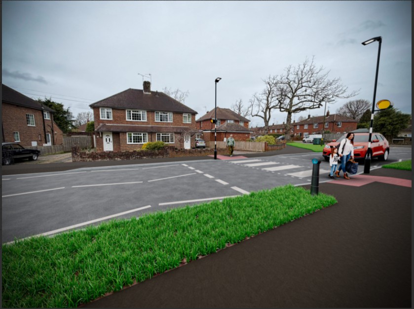
Highlands Road, Horsham, Artists impression of proposed zebra crossing improvements (image above)
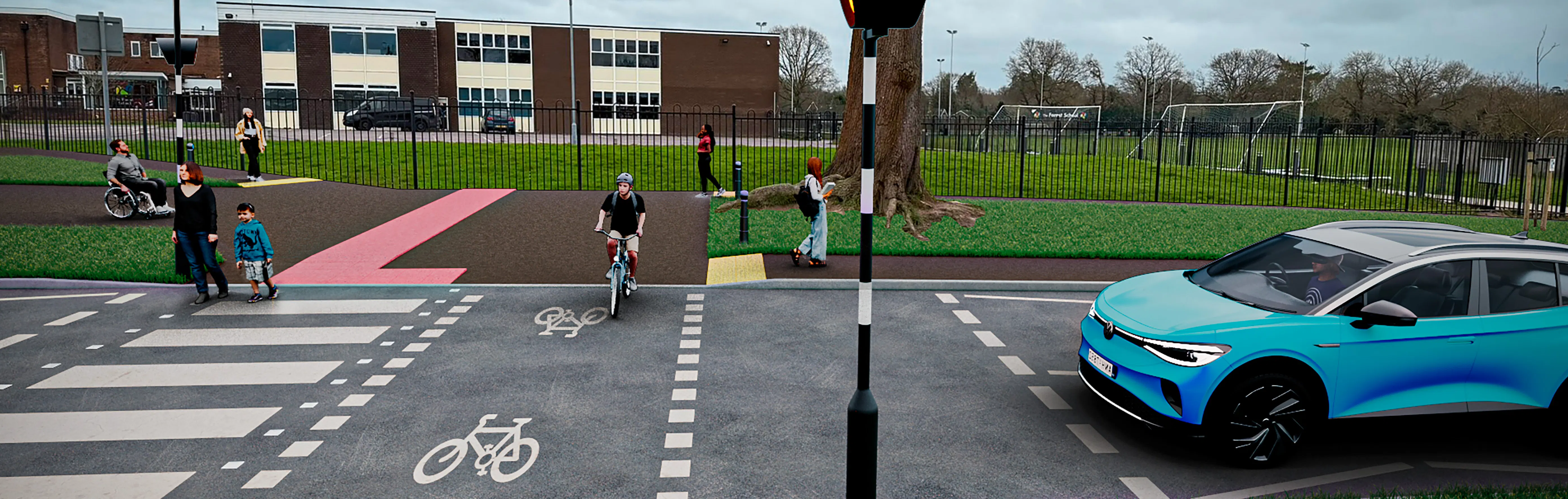
Bennetts Road Junction with Comptons Lane, artists impression of proposed parallel crossing improvements (image above)
Please refer to the Links on the right-hand side of the page for a consultation friendly Scheme Diagrams (see Scheme Diagrams and Technical Drawings box listed on the right-hand side of the page) or:
To view a detailed overview of the proposals please view the technical drawings (see Scheme Diagrams and Technical Drawings box listed on the right-hand side of the page).
The proposals have been designed in accordance with national design guidance for cycling, including the Local Transport Note 1/20 (opens in new window), which provides advice on delivering high quality cycle infrastructure.
The impact of the scheme on all road users has been considered to ensure that the needs of everyone are met, whilst facilitating safer and easier journeys for those walking, wheeling or cycling.
Funding the Improvements
We have been awarded funding from the Department for Transport’s Capability Fund to develop detailed design proposals for this scheme.
We will use the feedback raised through the consultation to inform our detailed design work and decide on the next steps for the project. Progress to the construction phase would be subject to the outcome of this consultation and additional funding being identified.
Strategic context
Horsham has been identified as a priority area for investment, and the scheme proposals are underpinned by West Sussex Transport Plan 2022-2036 (opens in new window). The Plan sets out how the county is intending to address a number of challenges, including climate change, congestion and road safety. The proposed improvements also form part of the Horsham Local Cycling and Walking Infrastructure Plan (LCWIP) (opens in new window), adopted in December 2020.
Local Cycling and Walking Infrastructure Plans (LCWIPs) are a strategic approach to identifying cycling and walking improvements required at the local level. They enable a long-term approach to developing local cycling and walking networks and form a vital part of the Government’s strategy to increase the number of trips made on foot or by cycle. The key outputs of LCWIPs are:
- A network plan for walking and cycling which identifies preferred routes and core zones for further development
- A prioritised programme of infrastructure improvements for future investment
- A report which sets out the underlying analysis carried out and provides a narrative which supports the identified improvements and network
Adopted in December 2020, Horsham’s Local Cycling and Walking Infrastructure Plan (LCWIP) provides a base for a walking and cycling network for the town centre, which will enable people to get more easily from A to B when making regular journeys such as commuting to work, trips to the shops, or to school or college.
Following consultation with local stakeholders, the LCWIP established six key walking and cycling corridors, connecting key residential and employment areas in Horsham to the town centre. The corridors are as follows:
- Corridor 1: North Horsham
- Corridor 2: Roffey
- Corridor 3: Forest School
- Corridor 4: Southwater
- Corridor 5: Broadbridge Heath
- Corridor 6: Warnham Mill
The extent of each corridor area is shown in the plan below.
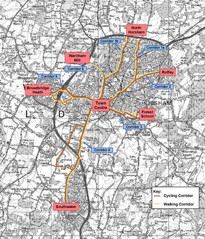
The Comptons Lane/ Bennetts Road scheme forms part of Corridor 3, Forest School to Town Centre, which has been subject to further development since the LCWIP was adopted.
Have your say!
Between Tuesday 23 June 2026 and Tuesday 04 August 2026 we want to hear your views on the types of improvements we are considering. Your feedback is important to us and will help shape the designs moving forward.
Please take this opportunity to let us know what you think by completing our survey, which can be accessed via the link at the bottom of this page. We will use your feedback from the survey, along with other information about the proposals, to refine our detailed designs.
We are holding a drop-in engagement event to give you the opportunity to speak and ask questions to a member of the project team. The event will take place on:
Wednesday 08 July 2026, between 4pm and 7pm
Main Hall, The Forest School, Comptons Lane, Horsham RH13 5NT (Map opens in new window)
Accessibility and alternative formats
If you require any of this information in an alternative format, then please contact us via email at activetravel@westsussex.gov.uk (opens in new window) or by telephone on 01243 642105 and we will do our best to assist you. If you are deaf or hard of hearing and have a BT Relay (UK) app (previously called the NGT texting app) installed on your computer, laptop or smartphone, you can contact us on 18001 01243 642105
Please note, you can use the Google Translate function to access this project in a range of different languages. The Google Translate widget can be found at the top left-hand side of the project page, where it sits just above the black West Sussex County Council ribbon.
For more information about the accessibility of this website, please see our Accessibility tab (opens in new window) at the foot of the page.
Survey web browser compatibility
Please use one of the browsers below when completing the survey to ensure it looks and works as it should. These are:
· Microsoft Edge version 86 and above
· Chrome version 86 and above
· Firefox version 78 and above
· Safari version 14 and above
Who's Listening
-

-
County Councillor for Horsham East and Leader of the County Council
West Sussex County Council

-