
Lancing and Sompting
Proposed cycling and walking improvements
This consultation ran from Monday 17th January to Monday 27th February 2023. The consultation report (opens in new window) has now been published. The East-West corridor (Green Route) is being taken forward into the County Council capital programme for further design and outline business case development. A summary update about the next steps (opens in new window) for this scheme and the linked A259 Shoreham to Brighton & Hove Boundary scheme that was consulted on at the same time is also available to view. The original consultation webpage text has been retained below. Latest information about the Lancing and Sompting scheme (opens in new window) is available to view.
West Sussex County Council is working to improve walking and cycling facilities across the County. By encouraging more walking and cycling, particularly for shorter journeys such as those to schools, we can help to reduce congestion on our already busy road network. We’ll also help to improve air quality and create safer, more pleasant places in which to live, work and do business.
Our West Sussex Transport Plan 2022 – 2036 (opens in new window) sets out how the county is intending to address a number of challenges, including climate change, congestion, and road safety. Adur and Worthing District Councils developed a Local Walking & Cycling Infrastructure Plan (opens in new window) that aims to improve the cycle network. To help address these issues we are now consulting on feasibility design options for three cycle routes within Lancing and Sompting developed through our Strategic Transport Investment Programme (STIP):
- Western Road corridor (Red Route): A27/Busticle Lane in the north to A259/Western Road in the south
- A2025 Grinstead Lane corridor (Orange Route): A27/Grinstead Lane in the north to A259/South Street in the south
- East-West corridor (Green Route): Lambleys Lane/Upper Brighton Road in the west to A2025 Grinstead Lane/Crabtree Lane in the east
We would like to hear your views on our designs for the proposed schemes within Lancing and Sompting by completing our survey (opens in new window). This survey is also available at the bottom of this webpage below the scheme summaries. The consultation is open until 11:59 p.m. on Monday 27 February 2023.
The schemes are not fully funded at this time, so your feedback will help us to shape further development of the designs and inform our decision on how to take the proposals forward, including helping to further build the case for these schemes. The schemes are expected to be funded using developer contributions and central Government grants that are intended for active travel schemes.
We are also consulting separately on feasibility designs for our A259 Shoreham towards Brighton cycle scheme. If you would like to find out more about this scheme, please visit our A259 Shoreham to Brighton & Hove page (opens in new window).
Scheme context
We previously commissioned the Shoreham Area Sustainable Transport Package to identify a package of transport improvements in the Shoreham area that would support local growth.
A network of cycle routes across Lancing and Sompting was one of the improvements identified.
A two-phased approach is being adopted to this consultation:
- Phase 1 – initial engagement
- Phase 2 – formal consultation
We are now undertaking the phase 2 formal consultation.
The initial engagement period (opens in new window) was carried out from 8 March to 12 April 2022. During this initial phase, the Lancing & Sompting scheme was presented alongside the B2144 Oving Road (Chichester) and A259 Shoreham to Brighton & Hover border schemes. However, we are now taking forward formal consultation on the schemes individually.
The Early Engagement Summary Report, which can be found in the Project Documents section, provides the full analysis of the responses received during the engagement period, along with details on the promotional materials and stakeholders involved. In summary, the responses given to the Lancing & Sompting scheme showed:
- 77% of respondents supported the scheme to some degree;
- 76% were in favour of new and improved crossings; and
- 52% thought all routes were equally important.
We have used all the feedback received to develop the design of the Lancing & Sompting scheme further for this consultation. Please review our information and plans before having your say via the survey at the bottom of this webpage.
About the proposals
A range of proposals are being considered along three main corridors through Lancing and Sompting to improve cycling connections to employment sites, education, retail, community and leisure destinations.
There are several development sites within the area, including New Monks Farm and West Sompting, which will lead to the creation of over 1,000 residential dwellings and new employment space. It is therefore important to develop proposals for high quality cycle infrastructure that could serve these developments as well as the existing communities.
These proposals form part of a package of sustainable transport and road junction measures being developed around Adur District to mitigate the impacts of development and improve the transport network for local communities, including addressing congestion. Please refer to the accompanying summary document (opens in new window) and map of transport measures in Adur (opens in new window) which provides more information about how these cycle routes support wider network measures.
For this consultation we have developed two potential north-south cycle corridors using Western Road/Busticle Lane to the west and A2025 Grinstead Lane/South Street to the east, as well as a potential east-west cycle route along West Street through Sompting, Cokeham Road and Crabtree Lane.
All three routes primarily consist of a two-way cycle lane, separated from the road and footway by a kerb. Where there are space constraints, some sections of ‘shared use’ footway and cycleway or on-road cycle provision is proposed.
Any improvements to the north-south corridors have the potential to connect to the National Cycle Network Route 2 (NCN2) that runs along the coast.
Western Road corridor (Red Route) - A27/Busticle Lane in the north to A259/Western Road in the south:
- In the north, the route begins as a ‘shared use’ cyclist and pedestrian path from the junction with the A27 on the eastern side of Busticle Lane.
- Continuing south, the shared use path transitions into a two-way cycle lane separated from the road and footway by kerbs.
- At the junction with Rectory Farm Road, due to space constraints, it converts back to a shared use path until after the junction with Cokeham Road.
- A ‘parallel’ pedestrian and cyclist crossing is proposed across Western Road North, between West Street and Cokeham Road, allowing users to transition onto the Green Route.
- Between Cokeham Road and just south of Ennerdale Drive, the route is predominantly a two-way cycle lane separated from the road and footway by kerbs, converting to shared use across side road junctions and bus stops where space is limited.
- The two-way cycle lane ends south of Ennerdale Drive due to space constraints at the railway bridge, so southbound cyclists must continue their journey on-road until the junction with St Paul’s Avenue, where cyclists would cross to a shared use path which starts on the western side of the road. In the northbound direction, cyclists would join the road at St Paul’s Avenue and cross to the cycle facilities on the eastern side of the road to the south of Ennerdale Drive.
- To the south of St Paul’s Avenue the route transitions into a two-way cycle lane separated from the road and footway by kerbs from the junction with Worthing Wastewater Treatment Works, again changing to shared use across side road junctions and bus stops, until the junction with the A259.
- A 4m wide staggered ‘Toucan’ crossing for cyclists and pedestrians would be provided across the A259 to connect users to the National Cycle Network Route (NCN2). This would be subject to traffic modelling to determine its impact on vehicle movements along the A259.
Please see the Western Road corridor (red route) map (opens in new window) for more details.
The proposed scheme would include the following features:
- ‘Raised tables’ across side road junctions to reduce vehicle speeds, improving the safety of and prioritising crossing pedestrians and cyclists.
- The consolidation of on-street parking to one side of the road is likely to be needed along with some other restrictions in certain areas to facilitate the cycle lanes.
- The southbound bus shelter located on Busticle Lane, near the junction with West Street, would be relocated on a new paved area and connected by a new footway.
- A widened crossing island at the junction with Cokeham Road to reduce the crossing distance for pedestrians and cyclists.
- Some minor kerb realignment may be necessary on Western Road North to accommodate the proposals.
There is the opportunity for the route to provide an onward connection to Halewick Lane, subject to National Highways proposals for the A27 Worthing & Lancing scheme.
A2025 Grinstead Lane corridor (Orange Route) - A27/Grinstead Lane in the north to A259/South Street in the south:
- The northern extent of the route starts as a ‘shared use’ cyclist and pedestrian path on the eastern side of Grinstead Lane, at the Lancing Manor Roundabout on the A27.
- As the route proceeds south, it transitions into a two-way cycle lane separated from the road and footway by kerbs, converting back to shared use across side road junctions and bus stops.
- South of the junction with North Farm Road, due to space constraints, the route reverts to shared use.
- The shared use path ends at the junctions with Kings Road and South Street, requiring southbound cyclists to transition onto the on-road ‘advisory’ cycle lanes. Northbound cyclists approaching from the south can join the off-road facility via a new ‘Toucan’ crossing for pedestrians and cyclists.
- The on-road advisory cycle lanes end at the junction with Roberts Road, where south of this, the road would become a 20mph zone marked by gateways with cyclists using the road.
Please see the A2025 Grinstead Lane (orange route) map (opens in new window) for more details.
The proposed scheme would include the following features:
- The potential to extend the 30mph speed limit closer to the Lancing Manor Roundabout, improving the safety for walkers and cyclists.
- ‘Raised tables’ across some side road junctions to reduce vehicle speeds, improving the safety of and prioritising crossing pedestrians and cyclists.
- Existing on-street parking on the western side of the road between Lancing Manor Roundabout and Orchard Way could be accommodated within the grass verge using ‘Grasscrete’, a reinforced surface covered with grass.
- Localised lane narrowing may be required to retain the existing pedestrian refuge islands.
- The right turn lane on Grinstead Lane, facilitating the movement into Curvins Way, would be removed.
- The four right turn lanes on Grinstead Lane into Crabtree Lane, Mash Barn Lane, Monks Avenue, and Grinstead Avenue, would be removed. An alternative option to maintain some of these would be to realign the kerb on the western side of the road.
- The existing single-phase ‘Pelican’ crossing to the south of Crabtree Lane would be replaced by a ‘Toucan’ crossing for cyclists and pedestrians enabling a connection to the Green Route.
- The existing staggered Pelican crossing south of North Farm Road and the existing single phase Pelican crossing to the north of Kings Road would also be replaced with single-phase Toucan crossings.
- The pedestrian refuge islands located either side of the railway bridge may be removed and replaced by the new Toucan crossings to the north and south.
- The consolidation of on-street parking to one side of the road is likely to be needed along with some other restrictions in certain areas to facilitate the cycle lanes/shared use paths, including on the approaches to the railway bridge.
- Some of the existing parking south of Kings Road would be ‘formalised’ with specific parking bays.
Onward connections:
- There is the opportunity for this route to extend through Lancing Manor Roundabout on the A27, subject to future National Highways proposals.
- A cycle link could be made along Orchard Way, providing a connection to the west.
- A potential onward cycle link could also be made via Mash Barn Lane and the New Monks Farm Strategic Development site, which would connect to Shoreham Old Toll Bridge.
- A potential link could connect to the National Cycle Network (NCN2) that extends along the coastline.
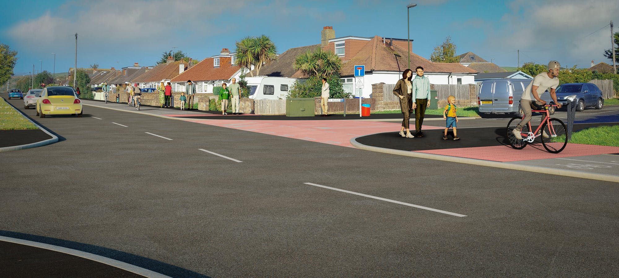
East-west corridor (Green Route) - Lambleys Lane/Upper Brighton Road in the west to A2025 Grinstead Lane/Crabtree Lane in the east:
- At the western extent, due to space constraints within Sompting Village, the route would begin on-road with a potential 20mph speed limit on Upper Brighton Road and West Street to improve safety for pedestrians and cyclists.
- A ‘shared use’ path for pedestrians and cyclists would begin east of the mini roundabout with Church Lane, which would be accessed via a dropped kerb. The shared path would continue along West Street on the southern side of the road until the junction with Busticle Lane.
- At this junction, the Green Route meets the Red Route, and a new ‘parallel’ pedestrian and cyclist crossing would extend across Busticle Lane to allow users to continue along the Green Route or the Red Route.
- The Green Route continues east along Cokeham Road on the northern side of the road, where the shared use path transitions to a two-way cycle lane separated from the road and footway by kerbs. Across side road junctions and bus stops, the path is converted back to shared use.
- At the junction with Boundstone Lane, the existing pedestrian refuge island would be widened to accommodate cyclists.
- The two-way cycle lane separated from the road and footway by kerbs continues along Crabtree Lane on the southern side of the road, converting back to shared use across bus stops and side road accesses, until the junction with Grinstead Lane, where it would join the Orange Route.
Please see the east-west corridor (green route) map (opens in new window) for more details.
The route would be accompanied by the following features:
- Improvements to the West Street/Church Lane mini roundabout in Sompting with the potential to reduce the crossing distance for pedestrians and cyclists.
- ‘Raised tables’ across side road junctions to reduce vehicle speeds, improving the safety of crossing pedestrians and cyclists.
- At the junction with Boundstone Lane and Crabtree Lane, there is the potential for additional crossing facilities to support access to Sir Robert Woodard Academy, subject to further assessments to determine volumes of pedestrian use at peak school times.
- The existing ‘Puffin’ crossing west of the Irene Avenue/Wembley Avenue junction on Crabtree Lane could be converted to a ‘Toucan’ crossing for cyclists and pedestrians. This would provide a cycle connection to Globe Primary School.
- Some existing on-street parking (for approximately six cars) may need to be removed on West Street, between the Test Road and Western Road North/Busticle Lane junctions, to provide space for the new cycle route.
- Some bus stops would be positioned on paved area ‘build outs’ and others would be relocated in order to accommodate the new cycle facility.
- Some existing crossing islands may need to be removed due to a narrower road width. An alternative option to maintain the crossing islands would be to realign the kerb on the opposite side of the road.
- Other crossing islands would be widened to improve the safety of pedestrians and cyclists.
Onward connections:
- At the western end of the scheme, there is the potential for an onward cycle connection along Upper Brighton Road towards Broadwater, subject to emerging local plan development proposals.
- At the junction with Cokeham Road, Boundstone Lane and Crabtree Lane, there is the potential to provide a northerly connection to The Sir Robert Woodard Academy.
- At the junction with Grinstead Lane, users would be able to continue their journeys north or south along the Orange Route, where they would use the crossing point south of Mash Barn Lane to access the off-road cycle facilities on the eastern side of Grinstead Lane.
- Users could also continue east via Mash Barn Lane and the New Monks Farm Strategic Development site, which would connect to Shoreham Old Toll Bridge.
Most of the designs utilise existing highway land however there are elements of the proposals that would require some land take from private landowners. We are in dialogue with the impacted landowners to develop these aspects of the proposals.
The proposed schemes will be subject to traffic assessments, which will be undertaken at a later stage to determine the impacts on traffic.
If insufficient funding is available to construct all three schemes, then it may be the case that a priority route needs to be identified for delivery. A question is included within the consultation survey about which of the routes are considered to be most important, and this information will be used to inform next steps for the schemes.
Have your say
We are holding two drop-in events so you can view our proposals and speak to members of the project team:
- Wednesday 15 February: Main Atrium at Sir Robert Woodard Academy, Upper Boundstone Lane, Sompting, Lancing, BN15 9QZ, from 4:00 p.m. to 8:00 p.m. The atrium can be accessed via the main reception.
- Wednesday 22 February: an online event, hosted on Microsoft Teams, from 7:00 p.m. to 8:00 p.m. Please register for the online event by emailing STIPActivetravel@westsussex.gov.uk
We are also holding two events for the A259 Shoreham to Brighton scheme:
- Wednesday 1 February: Main School Hall in Swiss Gardens Primary School, Swiss Gardens, Shoreham-by-Sea, BN43 5WH, from 4:30 p.m. to 8:00 p.m.
- Monday 6 February: Porter Room in the Southwick Community Centre, 24 Southwick Street, Brighton, BN42 4TE, from 4:00 p.m. to 8:00 p.m.
We would love to hear what you think about our proposals, so please tell us your views by completing the survey below the Accessibility Statement and survey web browser compatibility.
Next steps
Following the close of the consultation, your responses will be gathered and analysed before being incorporated into a consultation report. This will help us in deciding what amendments may be needed to the designs and the next steps for the scheme, including building the case for funding the schemes.
Accessibility statement
If you require any of the information for this project in an alternative format, please contact us on 01243 642105 or via email at LTP@westsussex.gov.ukExternal link)(External link) and we will do our best to assist you. If you are deaf or hard of hearing and have a BT Relay UK app (opens in new window)(External link) (previously known as NGT texting app) installed on your computer, laptop or smartphone, you can contact us on 18001 01243 642105 .
We are committed to making this website accessible, in accordance with the Public Sector Bodies (Websites and Mobile Applications) (No. 2) Accessibility Regulations 2018. Please view the West Sussex County Council Accessibility Statement (opens in new window) for further details. Information about the accessibility of the Your Voice Engagement Hub can be found by clicking on the 'Accessibility tab' which can be found right at the bottom of this page.
Where it exists, we will provide details of any project related content which is not fully accessible under a heading of 'Non-accessible content' below.
We are always looking to improve the accessibility of this website. If you find any problems not listed on this page or you think we are not meeting accessibility requirements, then please contact us on 0330 222 2146 or at haveyoursay@westussex.gov.uk.
Please note, you can use the Google Translate function to access this project in a range of different languages. The Google Translate widget can be found at the top left-hand side of the project page, where it sits just above the black West Sussex County Council ribbon.
Non-accessible content:
Artist impression - An artist impression of the proposals within Lancing and Sompting to show how the scheme may look once it is constructed. Additional text has been provided within the webpage to aid understanding.
Route maps - One overview map showing the three routes within Lancing and Sompting plus an additional three maps showing each route in more detail. Additional text has been provided within the webpage to aid the understanding of these maps.
Technical drawings - A more detailed version of the route maps. Additional text has been provided within the webpage to aid understanding.
Survey web browser compatibility
Please use one of the browsers below when completing the survey to ensure it looks and works as it should. These are:
- Microsoft Edge version 86 and above
- Chrome version 86 and above
- Firefox version 78 and above
- Safari version 14 and above
Who's Listening


Technical drawings
Project documents
-
 Lancing & Sompting Consultation Report (3.22 MB) (pdf)
-
Consultation and next steps update February 2024.pdf (70.1 KB) (pdf)
-
Lancing & Sompting scheme glossary (174 KB) (pdf)
-
Early Engagement Summary Report (5.75 MB) (pdf)
-
Lancing & Sompting Cycling & Walking Consultation Online Event presentation slides - Weds 22nd Feb.pdf (2.12 MB) (pdf)