
Westgate and Fishbourne Road East
An outline of the project details are provided below.
A summary report of engagement around the Westgate and Fishbourne Road East project (opens in new window) is now available to read.
Proposed Active Travel Improvements
West Sussex County Council is working to deliver improved cycling, wheeling and walking facilities. By encouraging more walking, wheeling and cycling, particularly for shorter journeys, we can help to reduce congestion on our already busy road network. We’ll also help improve air quality and create safer, more pleasant places to live, work and do business.
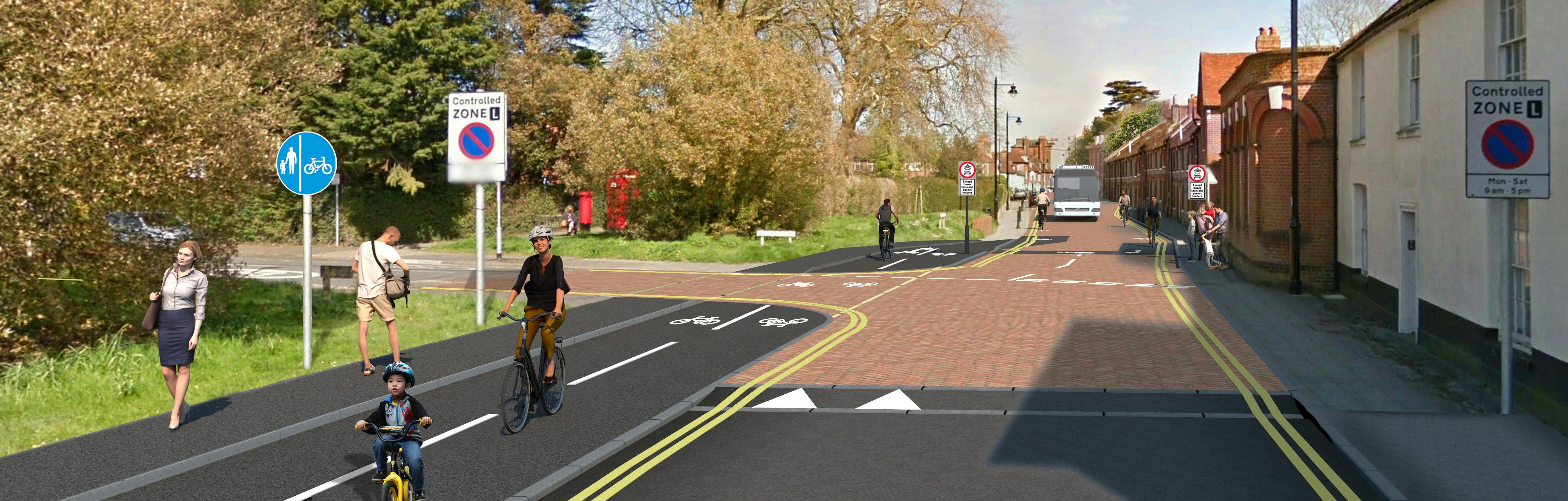
We are seeking feedback on the proposed cycling, wheeling and walking improvements between Fishbourne and Chichester City Centre, via Fishbourne Road East and Westgate (‘Route K’ as featured in Chichester District Council’s Local Cycling and Walking Infrastructure Plan).
Engagement and consultation
The purpose of this initial engagement period is to raise awareness of the scheme proposals and provide the earliest opportunity to give feedback. The comments we receive will help identify key constraints, issues and opportunities that will be used to help shape the proposals. Subject to the feedback we receive, we hope to carry out a consultation at a later date.
We would like to hear your views on the proposed schemes, so please complete the questionnaire and provide your comments on the interactive maps.
The engagement period is open until 11:59pm on 7 August 2023.
*Please note: on 28 June we updated the wording of the survey questions about the Western and Central Sections of the proposals to correct some inconsistencies and to remove an option from Q8. We also added an FAQ to provide more information about delivery vehicles accessing properties.
About the proposals
The proposals have been designed in accordance with national design guidance for cycling, including the Local Transport Note 1/20 (opens in new tab), which provides advice on delivering high-quality cycle infrastructure. The impact of the scheme on all road users has been considered, to ensure that the needs of everyone are met, whilst facilitating safer and easier journeys for cyclists, pedestrians and people who use mobility scooters or wheelchairs.
We have divided the proposals into three sections, which are described below.
1. Western Section: Fishbourne Road East
The western section of the scheme is focused on improving pedestrian and cycle access along Fishbourne Road East. Proposals include:
- A segregated two-way cycle track and footpath introduced on the north side of Fishbourne Road East that links with the existing segregated path through the A27 underpass and the proposed Chem Route to Emsworth.
- A kerb between the carriageway and the proposed two-way cycle track that would improve safety for cyclists.
- Raised tables introduced at junctions with St Christopher’s Close, Clay Lane, Rectory Gardens, Grove Park, Willow Court, and Dolphin Mews to give priority to pedestrians, cyclists and people using mobility scooters or wheelchairs. To ensure that vehicles turning at these junctions drive at slow speeds, the kerb lines would be made tighter, making it safer for pedestrians and cyclists to cross the road.
- Carriageway narrowed slightly and areas of grass verge removed to make space for the proposed cycle path.
- Existing slip road near Clay Lane to be removed and converted into a grass verge.
The segregated cycle track and footway would join the existing cycle path and footpath that leads to the Tesco Petrol Station and the existing cycle bridge over the railway line into Westgate.

2. Central Section: Westgate (between Sherborne Road and Parklands Road)
The section of Westgate between the railway cycle bridge and Sherborne Road is being redeveloped by the Whitehouse Farm developers. Plans for this area include parallel crossings on the Westgate arms of the proposed Southern Access Road and Sherborne Road, and off-carriageway links with Centurion Way and the foot/cycle bridge over the railway line to Fishbourne Road West.
The Route K scheme starts again at Sherborne Road. Two options are being proposed for the route along Westgate between Sherborne Road and Parklands Road. Both options are being put forward for feedback, but only one option would be introduced.
Option 1 – Traffic congestion reduction scheme
East of Sherborne Road junction to Parklands Road, vehicular access would be restricted to buses, taxis, and residents only. Cyclists would be directed to ride on the road with the existing cycle bypass, bollards and chicanes removed to make cycling easier. Consideration would be given for removing the existing road bumps. Additionally, the footway on both sides would be resurfaced and widened to follow the new constant-width kerb line along the road. Double yellow lines would be introduced on both sides of the road.
Option 2 – Proposed off-carriageway cycle scheme
A segregated two-way cycle track and footpath to be built on the north side of Westgate. A raised table would be installed at Tannery Close junction to prioritise pedestrians, with tighter kerb lines to ensure slow vehicle speeds and safer crossings for pedestrians and cyclists. The existing cycle bypass, bollards and road bumps would be removed. Double yellow lines would be introduced on both sides of the road.

3. Eastern Section: Westgate (between Parklands Road and Orchard Street Roundabout)
The aim of the Eastern section is to improve safety for cyclists and pedestrians on Westgate, between Parklands Road and Orchard Street Roundabout. This is a major route to the town centre. Two options are being put forward for feedback, but only one option would be introduced.
Proposals for the two options include a modified raised table junction at Parklands Road to slow vehicle speeds and a short, separated cycle path from Tannery Close to the east of Parklands Road. There will be no changes to the existing parking in this section. These proposals would be accompanied by either:
Option A – No motor traffic except for residents and buses
Introduction of a bus gate to restrict access to the section between Parklands Road and Henty Gardens to buses, taxis, and local residents only.

Option B – Proposed one-way traffic flow with contraflow bus lane east of Parklands Road
Proposed one-way traffic (eastbound) from Parklands Road to Orchard Street Roundabout, with a contraflow bus lane.

Background to the proposals
The proposed scheme is an integral part of the Chichester Local Cycling and Walking Infrastructure Plan (LCWIP) (opens in new tab), which was adopted by Chichester District Council in 2021. The LCWIP details the council’s proposed approach to delivering a high-quality network of safe, practical, and attractive walking routes for Chichester residents and visitors. One of the routes identified within the Chichester LCWIP was Route K: Freeland Close to Orchard Street. The County Council has now prioritised Route K for further investigation and development.
As well as helping to improve the health, well-being, and safety of West Sussex residents, it is hoped that improving routes for walking, wheeling and cycling and improving public transport, will support the local economy, reduce pollution, benefit users who do not have access to a car, and tackle climate change. This will also help achieve national targets for cycling and walking to be the natural first choice for many journeys with half of all journeys in towns and cities being cycled or walked by 2030.
Have your say
Between 27 June to 7 August, we want to hear your views on the proposed cycling, wheeling and walking improvements for Chichester. Your feedback is important to us at this early stage and will help shape the designs moving forward.
Please take this opportunity to let us know what you think by completing our survey (opens in new tab), which can also be accessed by visiting the link at the bottom of this page.
We also invite you to provide your comments on the Chichester Westgate interactive maps:
- Western Section: Fishbourne Road East Interactive Map (opens in new tab)
- Central Section: Westgate (between Sherborne Road and Parklands Road) Interactive Map (opens in new tab)
- Eastern Section: Westgate (between Parklands Road and Orchard Street Roundabout) Interactive Map (opens in new tab)
We will hold a drop-in engagement event, to give you the opportunity to speak and ask questions to a member of the project team.
The event will take place on Monday 3 July 2023, 4:30pm to 7pm at County Hall Chichester PO19 1RQ
Accessibility
If you require any of this information in an alternative format, then please contact us by phone 01243 642105 or via email at activetravel@westsussex.gov.uk and we will assist you.
If you are deaf or hard of hearing and have a BT Relay UK app (opens in new window) installed on your computer, tablet, laptop or smartphone, you can contact us on 18001 01243 642105. The BT Relay UK app has now replaced the NGT texting app.
For more information about the accessibility of this website, please see our Accessibility tab (opens in new window) at the foot of the page.
Please note, you can use the Google Translate function to access this project in a range of different languages. The Google Translate widget can be found at the top left-hand side of the project page, where it sits just above the black West Sussex County Council ribbon.

Who's Listening
-

-
JJ
Section plans
-
 1 Overview of scheme proposals (796 KB) (pdf)
-
2 Western Section: Fishbourne Road East (4.93 MB) (pdf)
-
3a Central Section: Between Sherborne Road and Orchard Street (Option 1) (5.89 MB) (pdf)
-
3b Central Section: Between Sherborne Road and Orchard Street (Option 2) (6.01 MB) (pdf)
-
4a Eastern Section: Westgate (Option A) (5.27 MB) (pdf)
-
4b Eastern Section: Westgate (Option B) (5.17 MB) (pdf)

