
FAQs
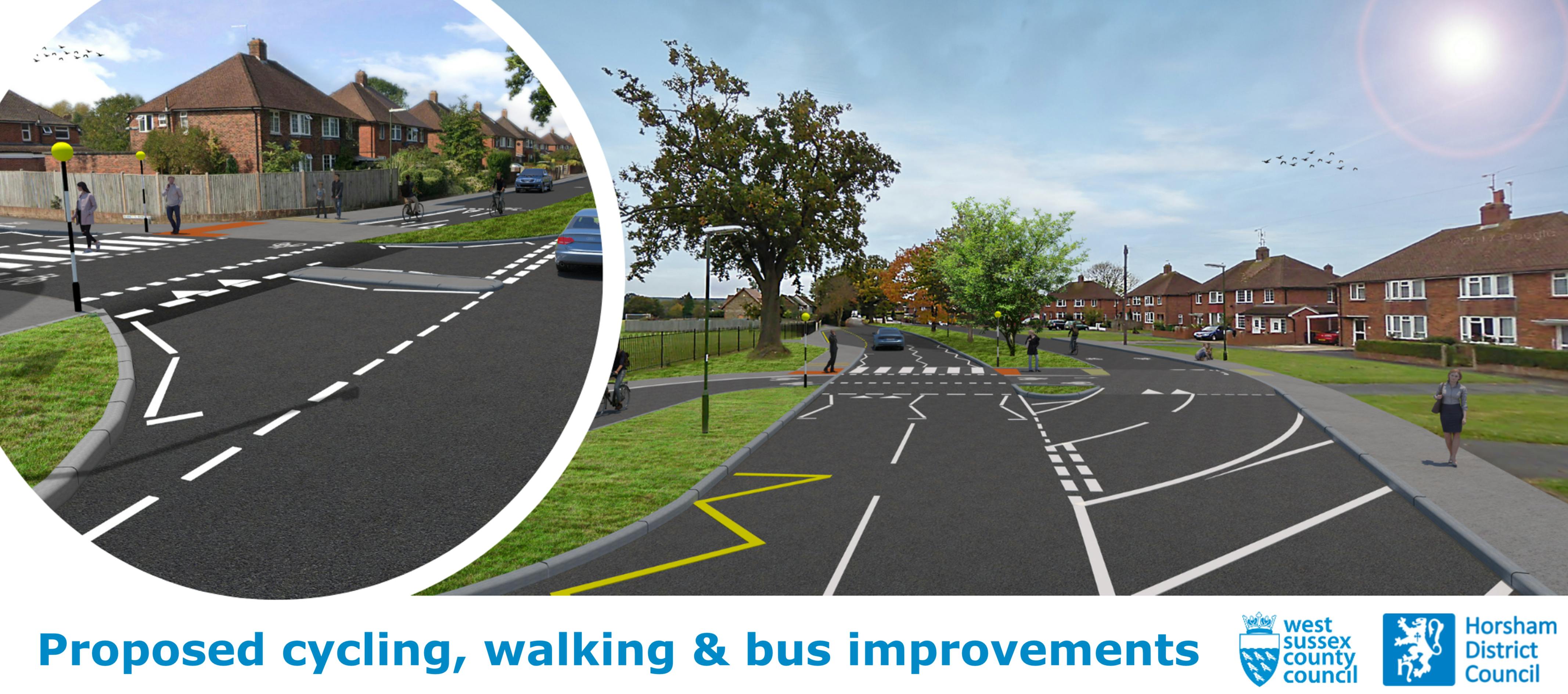
- Replacing the informal crossing, near the junction of Bennetts Road with Comptons Lane, with a raised zebra parallel crossing that has dedicated space for pedestrians and cyclists;
- Closing off the entrance to the service road from Bennetts Road, and providing a new entry point for vehicles from Comptons Lane. The service road would stay open to vehicles in both directions, and access to properties maintained. By closing one of the entry points, the proposals would make it safer and easier for pedestrians and cyclists to cross at the Bennetts Road junction;
- Widening footways and providing a segregated cycle and footway area with priority crossing outside the Forest School entrance, connecting with the existing shared-use path;
- Providing new bus laybys on Compton Lane, to help improve traffic flow.
What is the scope of this project?
The overarching aim of the project is to improve safety for pedestrians and cyclists in this area, particularly for the high volume of students travelling to and from Forest Secondary School. The proposed bus improvements will also improve traffic flow on Comptons Lane and reduce delay, particularly during busy school periods.
The final designs are still under development, and the proposals could change slightly depending on the feedback received throughout the consultation exercise. At a broad level, the scheme is looking to provide:
How are the improvements being funded?
Funding for the walking and cycling proposals will be dependent on a successful bid to the Tranche 4 of the DfT’s Active Travel Fund, which is expected to be announced later this year.
The proposed bus improvements are being funded through West Sussex County Council’s Local Transport Improvement Programme (LTIP).
It is important to note that, whilst both elements of the scheme are complementary, they are not dependent on one another. As such, if the Council’s bid to the Active Travel Fund is unsuccessful, the bus improvements could still be delivered, while alternative funding is sought for the walking and cycling proposals.
What standards are the proposals being designed to?
The project will seek to meet the guidance detailed for local authorities in the Government Local Transport Note 1/20 (Cycle Infrastructure Design). Beyond that, the Manual for Streets and the West Sussex Cycle Design Guide will also be considered.
How do you determine what type of provision is appropriate?
There are a variety of factors which we need to consider when determining what provision is most appropriate. This includes traffic conditions (such as speed and vehicle flow), the range of different users that will be travelling through the area, and location. We need to consider the range of users that will use the area and proposed new facilities. LTN 1/20 advocates infrastructure suitable for people from 8 to 80; we therefore need to ensure that any provision caters for the most vulnerable users. An Equality Impact Assessment will be undertaken should the scheme progress to the detailed design stage. Our proposals are being developed with the needs of people with protected characteristics.
How will the proposals make travel safer for pedestrians and cyclists?
The proposal includes a number of new raised pedestrian and parallel cycle crossings over the road and at junctions. This helps increase visibility and gives priority to people walking and cycling, as cars have to stop and give way to people crossing. This helps create a smoother journey for pedestrians and cyclists, and makes drivers more aware of people travelling on foot or by bike. The proposed new priority crossing at the school entrance helps create a safer journey for pupils walking and cycling to school, as it creates a seamless link into the school, without the need to negotiate with cars.
We are also proposing to provide a two-way cycle route along the service road, connecting with the existing shared-use path. This will improve safety as it means cyclists no longer have to travel on the pavement, or on the main road with general traffic, which is particularly hazardous during busy periods. It also reduces the conflict between cyclists and pedestrians, as each user group has their own dedicated space to travel.
The reconfiguration of the Comptons Lane/ Bennetts Road junction (and closure of the service road entrance at this point) will simplify movements in this location, making it an easier junction for all road users to navigate.
How will people travelling in cars be impacted?
The main impact for cars will be the closure of the service road access at the Comptons Lane/ Bennetts Road junction. The service road will stay open to vehicles in both directions, however, the proposals mean that vehicles will need to use the alternative access point to enter/ exit the service road. Access to properties will be maintained.
The proposed bus laybys outside the school will improve traffic flow on Comptons Lane, as it means buses will no longer need to stop on the road while people are getting on and off the bus. This means that cars will not get held up behind the buses while people are boarding. Therefore, the proposals will reduce delay for cars, particularly during busy school periods.
I am a resident on the Comptons Lane service road. How will access to my property be impacted by the proposals?
We are proposing to close the existing access to the service road at the Comptons Lane/ Bennetts Road junction for cars, replacing it facilities for pedestrians and cyclists. All residents travelling by car will therefore need to access their properties via the alternative entry point. Access for pedestrians will not be impacted.
How will parking be impacted?
We are not proposing to implement any new parking restrictions. It is expected that parking will be unaffected by the proposals.
Will any trees be impacted?
It is not currently proposed to remove any trees, however this will be dependent on the final scheme design. To provide the bus lay-by and cycle lane, this would require some loss of the existing grass verge outside the school entrance. However, it is expected that trees will be unaffected by the proposals.
How will you minimise disruption while the scheme is being constructed?
A scheme construction plan will be developed once the outcome of the consultation is known. Prior to any construction works taking place, the impact of the works on local people, businesses, road users and the environment will be assessed, and mitigation measures designed. This may include limiting working hours, noise mitigation and traffic management techniques to name a few.
We will ensure access to the school is retained throughout the duration of the construction works.
How much will the scheme cost?
At this early stage of design, a detailed costing exercise has not yet been undertaken. However, in order to be successful, any bid to the Government’s Active Travel Fund would need to demonstrate good Value for Money (VfM), which walking and cycle schemes generally do.
A detailed costing exercise will be undertaken once the outcome of the consultation is known.
When is the scheme likely to be constructed?
Subject to the outcome of the consultation, we would be looking to commence work on the bus improvements during 2023/ 2024.
The delivery of the walking and cycling improvements is dependent on a successful bid to the Department for Transport’s Active Travel Fund, which is expected to be announced later this year.
How do the proposals tie in with other schemes nearby?
West Sussex County Council is also progressing a wider cycling improvement scheme on Comptons Lane, north of the school. Some early design work has been undertaken but the proposals require further development and stakeholder engagement.
If delivered, the scheme would be funded through the Local Transport Improvement Programme (LTIP), and would tie in with the proposals outside the school, helping to create a connected and coherent route for cyclists.
What happens north/ south of the proposals, when cyclists reach the end of the proposed cycle lane? Where do they travel?
South of the Comptons Lane/ Bennetts Road junction, cyclists would be expected to travel on-carriageway with general traffic. At the entrance to Forest School, the proposed two-way cycleway ties in with the existing shared-use path, creating a seamless link into the school for people travelling by bike. North of the school on Comptons Lane, cyclists would be expected to travel on-carriageway with general traffic.
We are working up a series of proposals to connect the scheme with other cycle proposals to the north and south of the scheme, which would create a connected, safe and seamless link for people travelling by bike.
What are the next steps?
We will carefully consider all comments received during the consultation. Feedback received will be used to inform the detailed design phase and the next steps for the proposal. We will document the process and publish the results in a consultation report.
Subject to the outcome of consultation, West Sussex County Council intends to bid for the DfT’s Active Travel Fund later in the year. If successful, the funding would be used to finalise the proposals and construct the scheme.