Comptons Lane, Horsham (Engagement)
Comptons Lane, Horsham
Walking, Cycling and Bus Improvements
West Sussex County Council and Horsham District Council are working together to deliver improvements that will benefit residents, businesses and visitors alike. By encouraging more walking, cycling and bus use, we can help to reduce congestion on the region’s already busy road network. It will also help to improve air quality and create safer, more pleasant places in which to live, work and do business.
These proposals are focused on improving safety along Comptons Lane, near the Forest Secondary School, to the east of Horsham town centre. The proposals will help people travelling on foot or by bike more easily navigate the area, particularly the high volume of students travelling to and from the school. A key element of the scheme is to reconfigure the junction where Bennetts Road meets Comptons Lane, to improve the layout and ensure the junction can be safely and easily navigated by pedestrians and cyclists. The proposals also include improvements for buses on Comptons Lane, which is a busy route for buses, with up to 8 services turning up at the school twice a day. The scheme will help address safety concerns raised by the school, and help alleviate congestion along this already busy route.
We are seeking your feedback before 6 June 2022 to shape further development of the designs and inform our decision on how to take the proposals forward.
Complete the survey here (opens in new window).
About the proposals
Located close to the Forest Secondary School, the junction where Bennetts Road meets Comptons Lane offers limited provision for people travelling by bicycle, and can be difficult for pedestrians to navigate. The service road which runs adjacent to Comptons Road, connects into Bennetts Road in a T-junction arrangement which can create confusion for pedestrians, cyclists and drivers. The surrounding roads and junction get congested with traffic, particularly during school pick-up and drop-off times, with increased potential for conflict amongst people travelling on foot, by bike, bus, or in the car. Our proposals in this area aim to improve safety, particularly for the high volume of pupils travelling to and from The Forest School.
Comptons Lane is a busy route for buses, and at present there is not enough space to accommodate the high number of buses turning up at the school. This causes safety concerns and can create difficulties for students travelling to and from the school, with three child casualties recorded in recent years. The Forest School have identified a need for additional bus parking to support pupils accessing school transport safely. Our proposals will support this vision, by providing a new dedicated bus lay-by on Comptons Lane, allowing for the safe movement of pupils on and off the bus, and helping to alleviate traffic congestion along the route.
The proposed scheme is made up of two separate yet complementary elements:
1. Cycling and walking improvements:
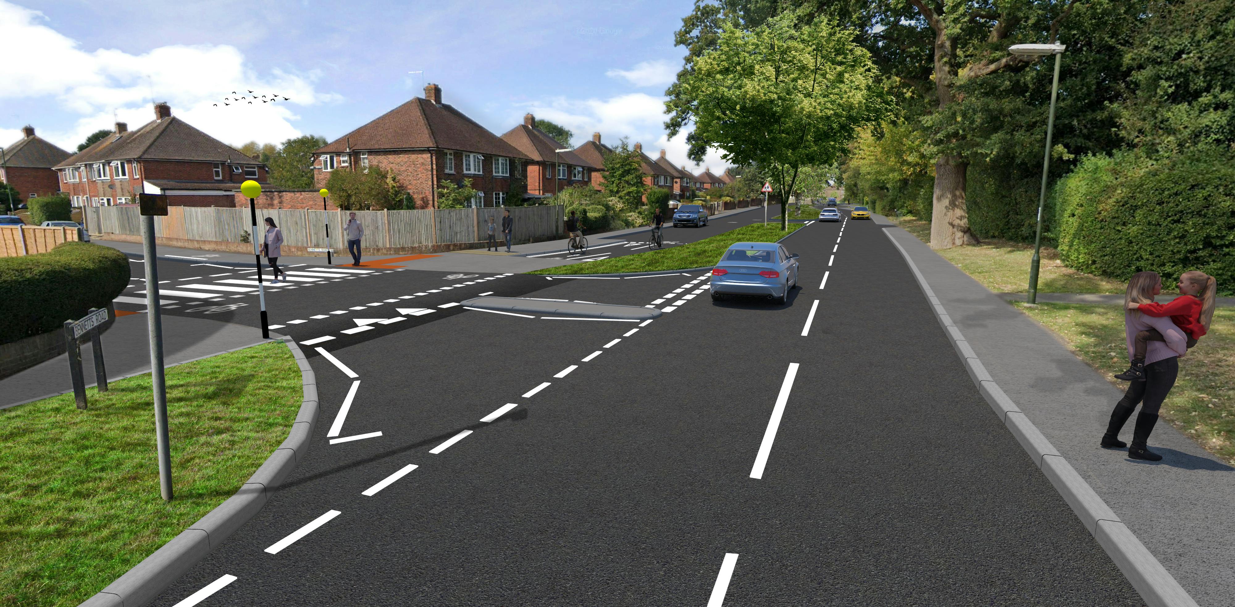
- Replacing the informal crossing, near the junction of Bennetts Road with Comptons Lane, with a raised zebra parallel crossing that has dedicated space for pedestrians and cyclists;
- Closing off the entrance to the service road from Bennetts Road, and providing a new entry point for vehicles from Comptons Lane. Access for pedestrians and cyclists from Bennetts Road would be maintained. The service road would stay open to vehicles in both directions, and access to properties maintained. By closing one of the entry points, the proposals would make it safer and easier for pedestrians and cyclists to cross at the Bennetts Road junction;
- Widening footways and providing a segregated cycle and footway area with priority crossing outside the Forest School entrance, connecting with the existing path outside the Forest School. This will replace some of the existing grass verge.
2. Bus improvement scheme:
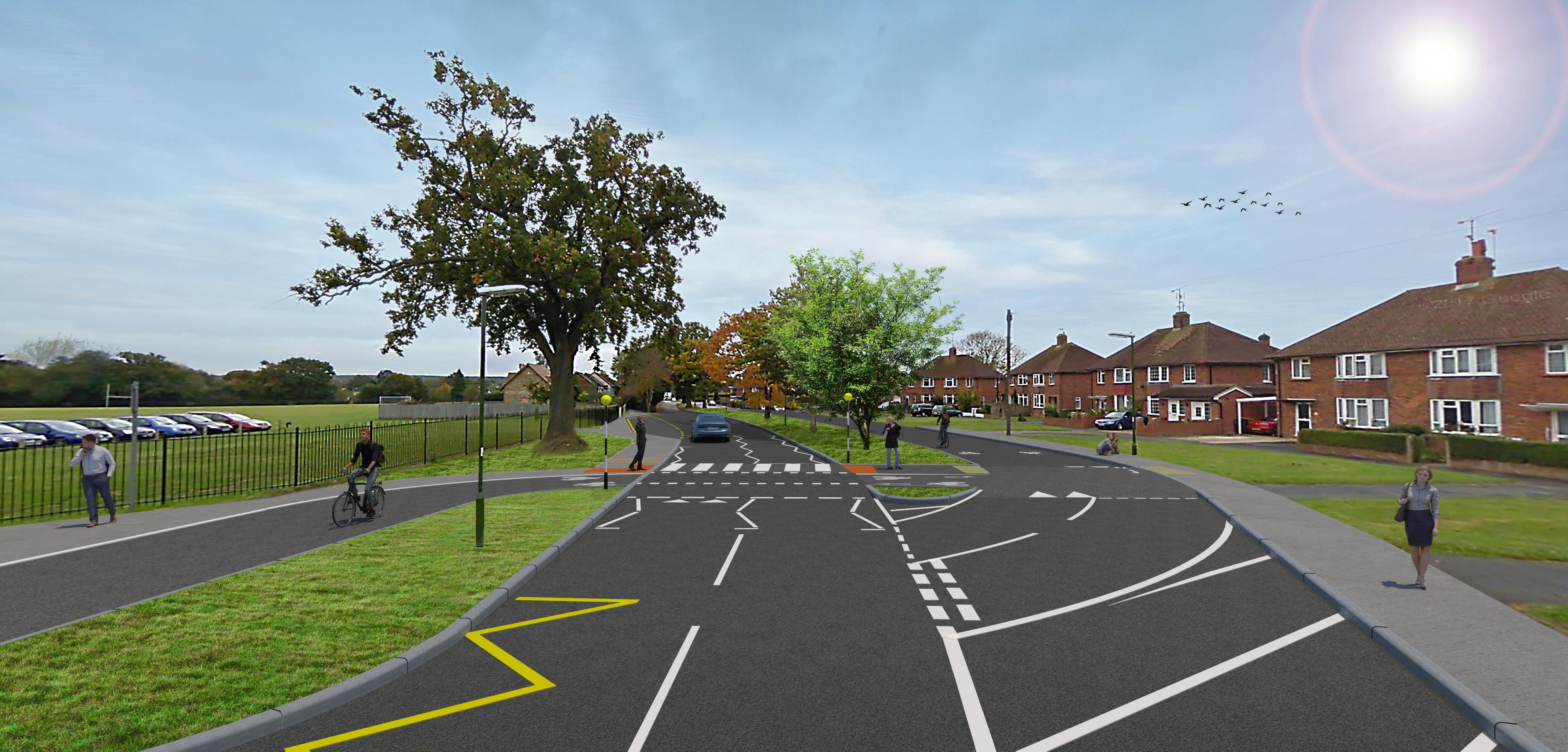
Providing a new bus lay-by outside The Forest School, to improve traffic flow and support safer movements of people getting on and off the bus. This proposal has been developed separately to the walking and cycling proposals, as part of a stand-alone bus improvement scheme (LTIP0042), which you may have already heard of. The scheme is a school-led initiative, to help better manage the safety issues that The Forest School has experienced with journeys to and from the school. Following earlier feedback on the proposal, we have altered the design of the bus lay-by so that we are now able to retain the oak tree outside the school.
Please refer to the consultation map (opens in new window) for a detailed overview of the proposals.
The proposals have been designed in accordance with national design guidance for cycling, including the Local Transport Note 1/20 (opens in new window), which provides advice on delivering high quality cycle infrastructure. The impact of the scheme on all road users has been considered, to ensure that the needs of everyone are met, whilst facilitating safer and easier journeys for cyclists, pedestrians and bus users.
View the proposals on a map (opens in new window). A copy of the technical drawing (opens in new window) is also available from the documents links on the right-hand side of the page.
Separately, during 2022/23 West Sussex County Council are planning to undertake feasibility work and engagement on a wider cycling improvement scheme focused on the section of Comptons Lane north of Forest School. This will complement the proposed scheme, helping to deliver a cohesive and connected network of cycle infrastructure across the town.
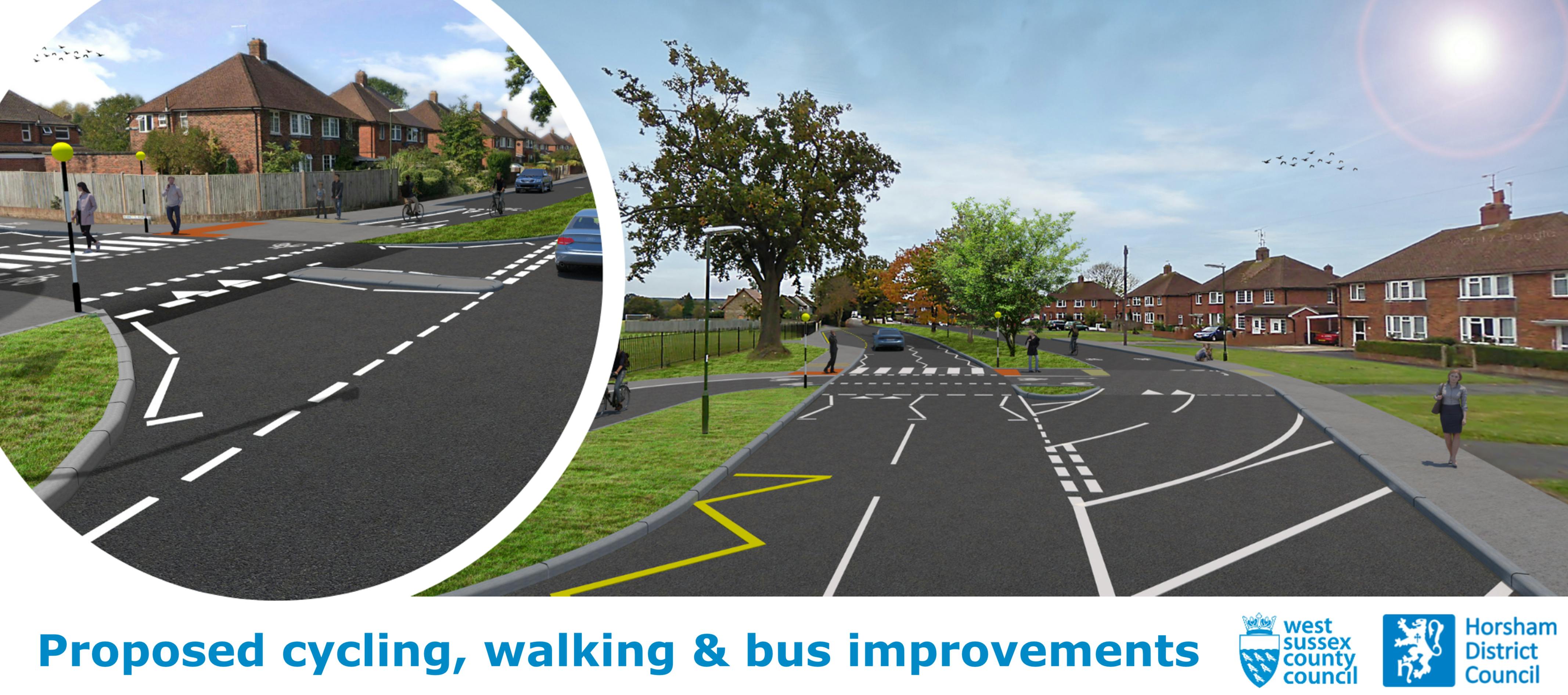
 Visualisation of the proposed changes at the Comptons Lane/ Bennetts Road junction
 Visualisation of the proposed changes outside The Forest School
 Funding the Improvements
We have been awarded more than £150,000 of investment from the Department for Transport’s Capability Fund.
This funding has enabled the Council to develop our next package of walking and cycling schemes.
The Comptons Lane scheme in Horsham (the focus of this webpage) forms one of three Local Cycling and Walking Infrastructure Plans (LCWIP) schemes currently under development.
We will use the feedback raised through the consultation to inform more detailed design work and decide on the next steps for the project. Subject to the outcome of the consultation, we would then be looking apply for the Government’s Active Travel Funding in Summer 2022.
The proposed bus infrastructure improvements are being progressed through our Local Transport Improvement Programme. Subject to the consultation outcome, the improvements could be constructed in 2023/ 2024. This element of the scheme will be funded by a combination of West Sussex County Council capital funding and S106 developer contributions.
It is important to note that, whilst both elements of the scheme (LCWIP proposals and bus improvements) are complementary, they are not dependent on one another. The bus improvements could therefore still be delivered if the walking and cycling proposals are not supported. Equally, the walking and cycling improvements could still progress if the bus infrastructure element is not supported.
Strategic context
Horsham has been identified as a priority area for investment, and the scheme proposals are underpinned by the emerging West Sussex Transport Plan 2022-2036 (opens in new window). The Plan sets out how the county is intending to address a number of challenges, including climate change, congestion and road safety. The proposed improvements also form part of the Horsham Local Cycling and Walking Infrastructure Plan (LCWIP) (opens in new window0, adopted in December 2020.
Local Cycling and Walking Infrastructure Plans (LCWIPs) are a strategic approach to identifying cycling and walking improvements required at the local level. They enable a long-term approach to developing local cycling and walking networks and form a vital part of the Government’s strategy to increase the number of trips made on foot or by cycle. The key outputs of LCWIPs are:
- A network plan for walking and cycling which identifies preferred routes and core zones for further development
- A prioritised programme of infrastructure improvements for future investment
- A report which sets out the underlying analysis carried out and provides a narrative which supports the identified improvements and network
Adopted in December 2020, Horsham’s Local Cycling and Walking Infrastructure Plan (LCWIP) provides a base for a walking and cycling network for the town centre, which will enable people to get more easily from A to B when making regular journeys such as commuting to work, trips to the shops, or to school or college.
Following consultation with local stakeholders, the LCWIP established six key walking and cycling corridors, connecting key residential and employment areas in Horsham to the town centre. The corridors are as follows:
- Corridor 1: North Horsham
- Corridor 2: Roffey
- Corridor 3: Forest School
- Corridor 4: Southwater
- Corridor 5: Broadbridge Heath
- Corridor 6: Warnham Mill
The extent of each corridor area is shown in the plan below.

The Comptons Lane/ Bennetts Road scheme forms part of Corridor 3, Forest School to Town Centre, which has been subject to further development since the LCWIP was adopted.
Have your say!
Between 25 April and 6 June 2022 we want to hear your views on the types of improvements we are considering. Your feedback is important to us at this early stage and will help shape the designs moving forward.
Please take this opportunity to let us know what you think by completing our survey, which can be accessed via the link at the bottom of this page.
We will use your feedback from the survey, along with other information about the proposals, to develop more detailed designs.
Privacy statement: West Sussex County Council and Horsham District Council will process this data in accordance with the 2018 Data Protection Act, General Data Protection Regulations and any subsequent relevant legislation. West Sussex County Council and Horsham District Council are registered as Data Controllers (Reg. No. Z6413427) and (Reg. No. Z7294458). For further information about our Data Controllers, please see West Sussex County Council's Privacy policy (opens in new window) and Horsham District Council's Privacy Policy (opens in new window).
The data will be collected, processed and analysed by our consultants, WSP, on behalf of West Sussex County Council for the purpose of this consultation only. Please read WSP’s Data Protection Policy (opens in new window) for more information.
Where it exists, we will provide details of any project related content which is not fully accessible under a heading of 'Non-accessible content' below.
Alternative Formats: If you require any of the information for this project in an alternative format, please contact us on 01243 642105 or via email at activetravel@westsussex.gov.uk and we will do our best to assist you. If you are deaf or hard of hearing and have an NGT texting app installed on your computer, laptop or smartphone, you can contact us on 18001 (01243 642105).
We are always looking to improve the accessibility of this website. If you find any problems not listed on this page or you think we are not meeting accessibility requirements, then please contact us on 0330 222 2146 or at haveyoursay@westussex.gov.uk.
Non Accessible Content
- Comptons Lane Technical Drawing- to assist in the understanding of the proposals (exempt)
- Comptons Lane Map- to assist in the understanding of the proposals (exempt)
Survey web browser compatibility
Please use one of the browsers below when completing the survey to ensure it looks and works as it should. These are:
- Microsoft Edge version 86 and above
- Chrome version 86 and above
- Firefox version 78 and above
- Safari version 14 and above