
FAQs
- Reviewing the available verge width (within the highway boundary) and assess the possibility of providing a segregated footway/cycleway along the whole length of the route.
- Reviewing the bus stop layout at Franklin Place, to include segregated facilities for pedestrians and cyclists.
- Reviewing side road junction layouts to assess the possibility of reinforcing cyclists priority over turning vehicles at the junctions.
- Explore the possibility of providing safe crossing facilities to enable walkers and cyclists to cross from the proposed route (on the north) to the south of Oaklands Way and Spitalfields Lane.
- Improving traffic signs along the route and at side road junctions.
- Developing the required height difference between the proposed shared footway/cycleway and the carriageway to ensure that the recommended LTN 1/20 guidance on minimum gradients can be achieved along the route, wherever possible.
- Land to the south of the A27 that is part of the Fishbourne Lakes site;
- Land adjacent to Portfield Way that is part of the Portfield Retail Park;
- Land adjacent to the footpath running between the Portfield cemetery and the former football ground; and
- A small section to the east of Tozer Way fronting the A285 in the vicinity of the Newell Centre/St. Pancras Church building.
Why is the scheme required?
We are working to improve walking, cycling and public transport networks across West Sussex. By encouraging more walking and cycling, particularly for shorter journeys, we can help to reduce congestion on our already busy road network. We’ll also help to improve air quality and create safer, more pleasant places in which to live, work and do business.
Underpinning our approach to improving the transport network within the county is the West Sussex Transport Plan 2022-2036 (opens in new window). It sets out how the County Council is intending to address a number of challenges, including climate change, congestion, public health and road safety.
The routes will help achieve national targets for cycling and walking to be the natural first choice for many journeys, with half of all journeys in towns and cities being cycled or walked by 2030.
How much will the scheme cost and how is it being funded?
At this early stage of design, a detailed costing exercise has not yet been undertaken, however we expect the scheme costs to be in line with similar schemes being delivered around the country. To be successful, the schemes would need to demonstrate good value for money and are subject to the development of business cases.
An external funding stream would be used to deliver the proposals. This includes developer contributions and central Government grants that are intended for active travel schemes.
Congestion is more of an issue in the area, why are you not improving this first?
The West Sussex Transport Plan 2022-2036 (opens in new window) identified the need for improvements to highways, public transport and active travel facilities to tackle congestion. The County Council and organisations such as National Highways are developing a range of improvements so that they can be delivered as funding opportunities arise.
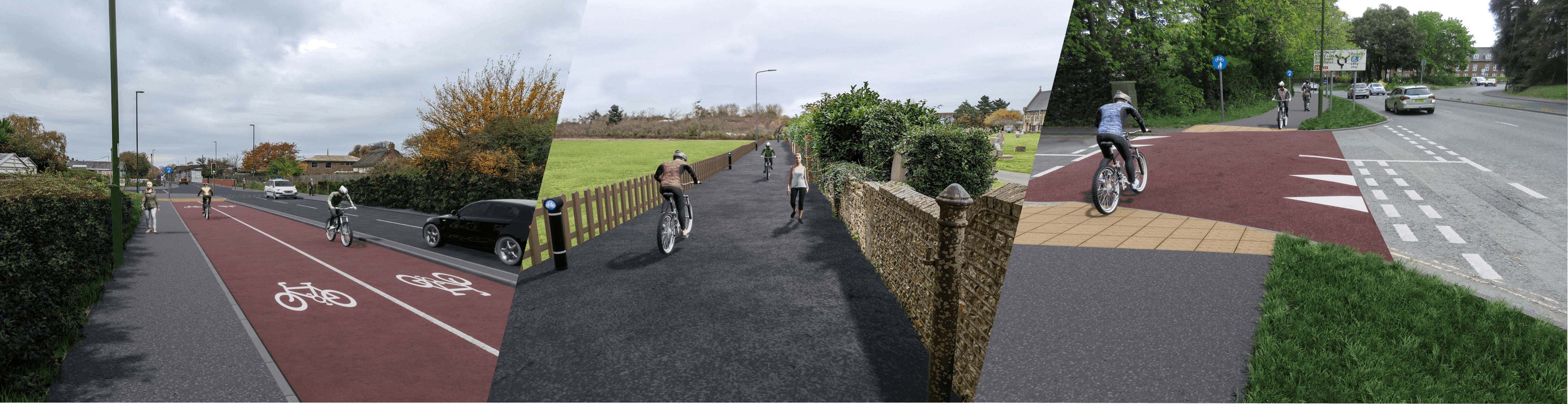
By providing a safe space for cycling that is off the carriageway, we aim to encourage more people to cycle within Chichester, particularly those people that are less confident cyclists. The routes would provide connections towards a number of key destinations within Chichester and beyond (such as Tangmere), including schools, employment, retail and leisure destinations such as Portfield Retail Park and the Shopwyke Lakes development. The scheme would therefore make it easier for people to walk or cycle to these destinations, and more widely across Chichester, rather than using their vehicles. The A285 Chichester to Tangmere Sustainable Transport Corridor scheme would also have the potential to improve public transport by providing bus priority traffic signal technology.
Have you taken on board the concerns raised by residents about the temporary cycle lane installed along the A286 Oaklands Way during COVID?
In response to COVID-19 restrictions in 2020, the County Council introduced a temporary ‘pop-up’ cycle lane along A286 between Northgate Gyratory and New Park Road roundabout. We have listened to the feedback received about that scheme, which included some concerns over a lack of road capacity leading to congestion and limited passing opportunities for emergency vehicles, and have proposed a scheme that we believe responds to the concerns raised at that time.
Could on-street parking be affected by the proposals?
In order to accommodate the cycling and walking facilities of the A285 Westhampnett Road corridor, it may be necessary to restrict some on-road parking in some areas. The impacts on removing this parking will be further assessed as the scheme is developed. The A286 Oaklands Way scheme does not affect any existing allocated parking.
Are the designs LTN 1/20 compliant?
The Government’s Local Transport Note (LTN) 1/20 (opens in new window) provides guidance and good practice to local authorities for the design of high-quality cycle infrastructure.
The shared-use (option 1) feasibility design that we are consulting on for A286 Oaklands Way has been through a LTN 1/20 design review, and a number of criteria were highlighted as needing to be addressed, these are summarised below:
The segregated cycle lane and footway (option 2) proposals have been developed in response to both the earlier engagement feedback and the LTN 1/20 review. Although this option has not been through a full feasibility level assessment, given the available space between the highway boundary and carriageway (5.1m along most of the route), we are proposing that a fully segregated scheme could be delivered along most of the route. It is believed that this segregated option can be accommodated without the need to reduce eastbound traffic lanes along Oaklands Way, however more detailed survey of the space available is required at the next design stage to confirm this.
For the A285 Chichester to Tangmere Sustainable Transport Corridor scheme, the LTN 1/20 guidance has informed our proposals and the scheme largely consists of two-way cycle tracks, separated from the carriageway and footway, with a minimum width of 2.5m.
However, there are some sections where it has not been possible to provide this standard of provision due to the limited availability of highway space. In these sections we have proposed shared use paths.
I live along one of the proposed routes. Will I still be able to access my driveway?
Yes, existing access to driveways will be maintained via dropped kerbs.
Are you considering any bus priority measures/improvements to services?
The range of improvements we are considering primarily focus on improved facilities for walking and cycling, with some improvements to junctions. However, where these facilities intersect a bus stop, we will explore ways in which to upgrade them. On the A285 Chichester to Tangmere Sustainable Transport Corridor we are also considering the use of traffic signals to detect and prioritise buses, which would improve their reliability.
Will the proposals link up to existing walking/cycling infrastructure?
Both corridors in Chichester have the potential to connect to other walking and cycling routes in the area, such as the Salterns Way cycle route/ Chichester Harbour Circular/ Chichester Harbour Northern Cycle route/ Centurion Way Cycle Path and proposed LCWIP routes.
The A285 Chichester to Tangmere Sustainable Transport Corridor proposes to connect to the Tangmere Strategic Development, Shopwyke Lakes development and the recently opened pedestrian/cycle over-bridge linking to Westhampnett village via Coach Road. The scheme would also link to Portfield Roundabout and would travel over the A27 by a new pedestrian/cycle over-bridge, which is to be delivered by Shopwyke Lakes Development.
Does the scheme require any land take / is my property at risk?
At this stage it is anticipated that the majority of the construction works can take place within the existing highway boundary or on land owned by West Sussex County Council. However, some non- highway land would be required, including at the following locations:
We are either in dialogue with the impacted landowners or seeking clarification on land ownership to develop these aspects of the proposals.
What are the next steps?
We will carefully consider all comments received during the consultation. Feedback received will be used to inform the detailed design phase and the next steps for the proposals and will help to build the case for funding the schemes. We will document the process and publish the results in a consultation report.
When would you expect the schemes to be built?
Future progression of the schemes will be informed by the outcomes of this consultation. Further design and consultation would be needed before any schemes could be constructed. Construction would be subject to a business case, all relevant statutory processes (e.g, planning) and securing central Government funding for scheme delivery. It is therefore not possible to confirm a delivery timescale at this stage.
If the scheme is to go ahead, will there be road closures during construction?
Before any construction on the scheme starts, a Construction Management Plan will be published to minimise the impact on the local community as much as possible. This will detail any temporary road closures, along with changes to access for pedestrians and cyclists as well as diversion routes.
I can’t attend the in-person events, but I want to speak to a member of the project team, what should I do?
You can either email any comments or questions to the team at LTP@westsussex.gov.uk or you can telephone 01243 642105. If you are deaf and have the NGT app installed on your PC, laptop, or mobile phone, you can contact us on 18001 01243 642105.