
B2144 Oving Road, Chichester
Walking and cycling improvements
This consultation ran from Tuesday 27th September to Monday 14th November 2022. The consultation report (opens in new window) has now been published along with a summary note (opens in new window) about the outcomes of the consultation. The original consultation webpage text has been retained below.
West Sussex County Council is working to improve walking and cycling facilities across the county. By encouraging more walking and cycling, particularly for shorter journeys, we can help to reduce congestion on our already busy road network. We’ll also help to improve air quality and create safer, more pleasant places in which to live, work and do business.
Underpinning our approach to improving the transport network within the county is the West Sussex Transport Plan 2022 – 2036, which was approved in April 2022. The document sets out how the county is intending to address a number of challenges, including climate change, congestion, and road safety. To address these issues, we are looking to implement a series of transport improvement schemes across the county.
Three locations have been identified through wider Sustainable Transport Study areas, undertaken as feasibility studies for Chichester, Shoreham and Lancing & Sompting, as part of our rolling Strategic Transport Investment Programme (STIP). These studies looked for opportunities to provide new and improved facilities for all users, but especially walkers and cyclists. We have now developed feasibility design options for the following route:
- B2144, Oving Road, Chichester, between the A27/Oving Road junction in the east and the A259 Whyke Road in the west
We are preparing feasibility design options for the A259 Shoreham to Brighton & Hove border and Lancing & Sompting schemes. Therefore, their consultations will follow at a later stage.
We are now seeking your views on our designs for Oving Road. The consultation is open until 11:59pm on Monday 14 November 2022. Your feedback will help us to shape further development of the designs and inform our decision on how to take the proposals forward.
We would love to hear what you think of our proposals for Oving Road, so please tell us your views by completing the survey at the end of this page.
About the proposals
We have developed two design options for Oving Road that also extend along sections of Florence Road, Pound Farm Road and the A259 Whyke Road. We would like to know which option you would prefer to be taken forward, so please complete the survey at the bottom of this page to tell us your views.
Option 1
Option 1 primarily consists of widening the existing footway to create a shared use footway and cycleway. The location of this facility would be:
- On the northern side of the carriageway from the newly improved junction with the A27 Chichester bypass to the pathway of Kelby Road, before switching to the southern carriageway until the junction with Florence Road/St James’ Road;
- Extending down Florence Road, providing a link to Florence Park;
- Running along Pound Farm Road on the northern side of the carriageway until the junction with the A259 Whyke Road; and then
- Continuing south down the eastern side of the A259 Whyke Road where it would connect to the existing Toucan crossing and join up to the cycle route that takes users into the city centre.
In order for this to be achieved some narrowing of the carriageway may be required in places, although all of the roads would continue to operate as two-way. Some narrowing of the grass verge would also be needed.
Parking restrictions would be put in place along parts of the road to protect the shared use paths and maintain highway space, although this would only be in areas where there is adequate off-street parking.
Measures would also be introduced to make it safer and easier for pedestrians and cyclists to cross side roads, by lowering vehicle speeds on their approach to junctions. These facilities include:
- A raised table across Charles Avenue;
- Continuous footways across smaller side road junctions on Oving Road and Pound Farm Road; and
- Footway build outs that reduce the carriageway width along smaller side road junctions on Oving Road and Pound Farm Road.
The map below provides an overview of the proposals for Option 1. For more detailed plans, please refer to our technical drawings in the Project Documents section, which are broken down into three maps as presented below.

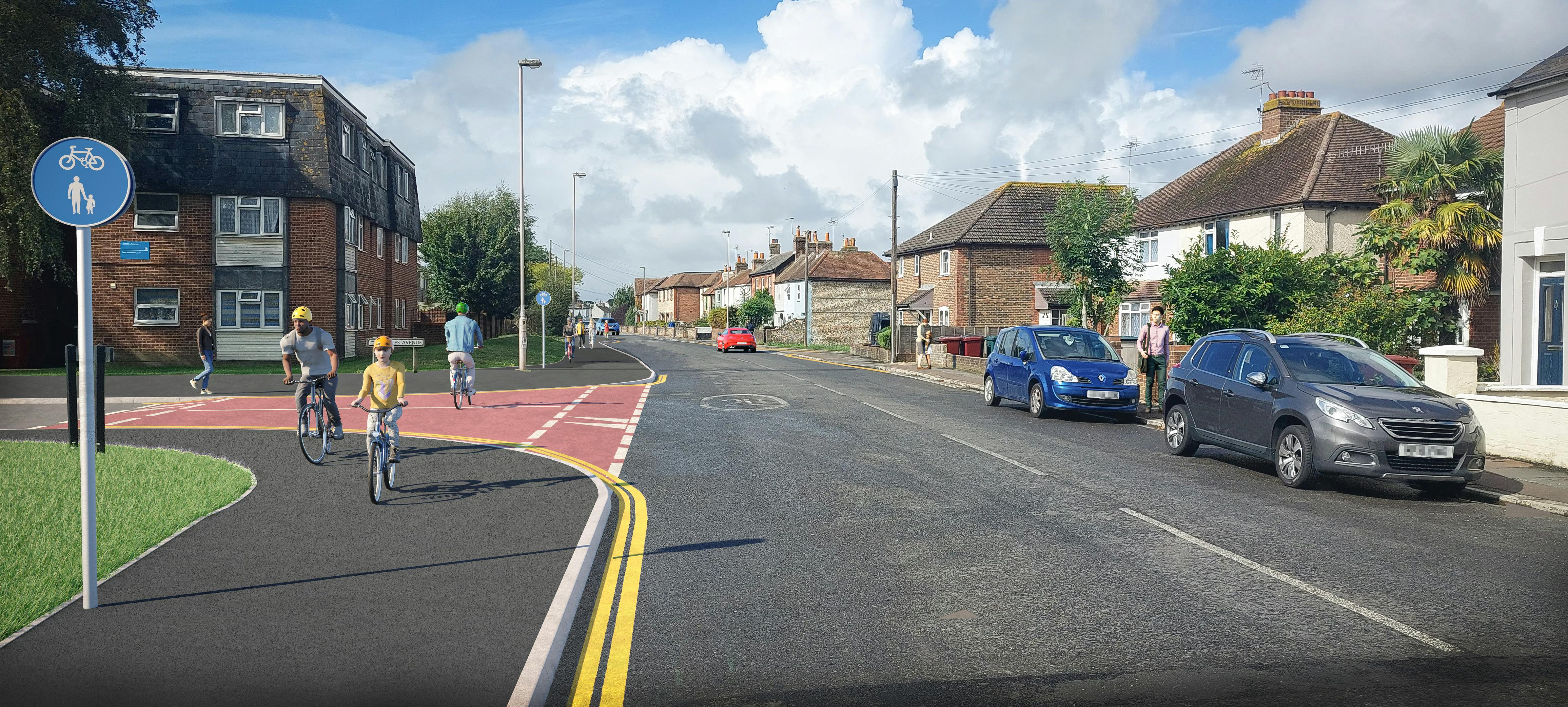
The image below is an artists impression of Option 1. It shows the shared use paths along Oving Road, the raised table across Charles Avenue and in the distance, the footway build out.

Option 2
The second option would introduce advisory cycle lanes along Oving Road. These lanes would extend on the westbound carriageway between the junctions of the A27 Chichester Bypass and Leatherbottle Lane, before switching to the eastbound carriageway between the junctions of Leatherbottle Lane and St James’ Road/Florence Road.
Between St James’ Road/Florence Road junction and the A259, westbound cyclists would be expected to continue along Oving Road. For eastbound cyclists coming from the A259, they would be directed onto Pound Farm Road and Florence Road before connecting to the advisory cycle lanes on Oving Road.
The advisory cycle lanes would be complimented by no waiting at any time restrictions in order to protect the cycle lanes and increase the visibility of side roads.
From the junction with St James’ Road/Florence Road to the A259 Whyke Road, Oving Road would be converted to one-way in the westbound direction for vehicles. This would improve the visibility for all users, creating a safer environment for cyclists and pedestrians whilst maintaining residents’ on-street parking.
Florence Road and Pound Farm Road would remain as two-way in order to provide eastbound access to Oving Road.
There would also be measures to make it safer and easier for pedestrians and cyclists to cross the roads along the route. These facilities include:
- Footway build outs that reduce the carriageway widths on the junctions of Green Lane and Guilden Road; and
- A traffic island on the junction with the A259 Whyke Road to assist westbound cyclists in exiting the junction.
The map below provides an overview of the proposals for Option 2. For more detailed plans, please refer to our technical drawings in the Project Documents section, which are broken down into three maps as presented below. 
The scheme is intended to improve the connections between areas to the East of Chichester, such as Shopwhyke and Tangmere, to the city centre. This is especially important given the 585 new homes being built at Shopwyke Lakes. The proposals would make it safer and easier for people to reach employment and leisure opportunities by walking or cycling, reducing the reliance on the private car.
This would not only help to make people feel better connected to the goods and services on offer in the centre of Chichester but would also reduce congestion and improve air quality.
Key design challenges
It is important to note that there are a number of challenges in the area that have influenced the design of the scheme.
The proposed continuous footway across Chequers Place that forms part of option 1 would require some land take. We are seeking permission to open a dialogue with the private landowner in order to develop this part of the proposal.
Residential properties closely border the carriageway along sections of Oving Road, particularly the western areas nearest the A259. This limits the amount of highway space available, meaning footways here are narrow with no room to widen. There is also on-street parking that needs to be maintained as some properties do not have the option to park off-street. This means we are not proposing any dedicated cycling facilities along Oving Road between the St James’ Road/Florence Road junction and the A259 Whyke Road.
The grass verge between the junctions of Chequers Place and St James’ Road/Florence Road has telecommunications equipment close to the kerb. It would therefore require costly diversions to widen the carriageway here.
Strategic context
In 2019, we commissioned the Phase 1 Chichester Area Sustainable Transport Package Feasibility Study to identify a list of transport infrastructure improvements to support the delivery of the Chichester Local Plan (2014-2029).
The study included a general review of existing conditions, collision analysis, and high-level potential options for cycle facilities.
One of the priorities identified from this was the Sustainable Transport Corridor, with improvements to sustainable transport facilities along Oving Road.
A two-phased approach is being adopted to the scheme:
- Phase 1 – initial engagement
- Phase 2 – formal consultation
The initial engagement period was carried out from 8 March to 12 April 2022. During this first phase, the Oving Road scheme was presented alongside the Lancing & Sompting and A259 Shoreham to Brighton & Hover border schemes. However, for this formal consultation we have decided to consult on them separately. The consultations for the other two schemes will take place at a later stage.
The Early Engagement Summary Report, which can be found in the Project Documents section, provides the full analysis of the responses received during the engagement period, along with details on the promotional materials and stakeholders involved. In summary, the responses given to the Oving Road scheme showed:
- 74% of respondents supported the scheme to some degree;
- 76% were in favour of a dedicated space for cycling; and
- 65% supported raised tables along the side road junctions.
We have used all of the feedback received to develop the design of the Oving Road scheme further for this consultation. Please review our information and plans to see what we are proposing along the route.
Have your say
We are holding a drop-in event so you can view our proposals and speak to members of the project team.
This will be held on Thursday 20 October 2022 in the Main Hall, Portfield Primary Academy, St James’ Road, Chichester, PO19 7HA, between 4pm and 8pm.
Car parking is located at the rear of the school, which is accessed via Armadale Road. The closest bus stops are located on St James’ Road next to the junction with Farndell Close.
We would love to hear what you think of our proposals for Oving Road, so please tell us your views by completing the survey below.
Following the close of the consultation, your responses will be gathered and analysed before being incorporated into a consultation report. This will help us in deciding the final design and next steps for the scheme.
Accessibility Statement
If you require any of the information for this project in an alternative format, please contact us on 01243 642105 or via email at LTP@westsussex.gov.uk(External link)(External link) and we will do our best to assist you. If you are deaf or hard of hearing and have a BT Relay UK app (opens in new window) External link)(External link)installed on your computer, laptop or smartphone, you can contact us on 18001 01243 642105 .
We are committed to making this website accessible, in accordance with the Public Sector Bodies (Websites and Mobile Applications) (No. 2) Accessibility Regulations 2018. Please view the West Sussex County Council Accessibility Statement for further details. Information about the accessibility of the Your Voice Engagement Hub can be found by clicking on the 'Accessibility tab' which can be found right at the bottom of this page.
Where it exists, we will provide details of any project related content which is not fully accessible under a heading of 'Non-accessible content' below.
We are always looking to improve the accessibility of this website. If you find any problems not listed on this page or you think we are not meeting accessibility requirements, then please contact us on 0330 222 2146 or at haveyoursay@westussex.gov.uk.
Please note, you can use the Google Translate function to access this project in a range of different languages. The Google Translate widget can be found at the top left-hand side of the project page, where it sits just above the black West Sussex County Council ribbon.
Survey web browser compatibility
Please use one of the browsers below when completing the survey to ensure it looks and works as it should. These are:
- Microsoft Edge version 86 and above
- Chrome version 86 and above
- Firefox version 78 and above
- Safari version 14 and above
Non-accessible content
Early Engagement Summary Report (PDF - This presents a summary of the Phase 1 Early Engagement that was undertaken in Spring 2022. It outlines the materials that were created (website, survey, interactive maps, posters and postcards) along with who was engaged with. It also presents the results of the responses received to the survey, interactive maps, letters and emails. Overall, it showed the Oving Road scheme received a high level of support compared to opposition.)
Overview maps for Option 1 and 2 (PDF - The maps show an overview of the technical drawings, highlighting where key features of the scheme would be located, including the shared use paths, advisory cycle lanes, raised tables and footway build outs.)
Artist impression of Option 1 (JPG - The image shows what Option 1 could look like if it were to be constructed. The image looks west down Oving Road, with the junction of Charles Avenue on the left hand side. It shows the proposals would increase the width of the existing footway to create a shared-use path, along with the associated shared use signage. Across Charles Avenue there would be a raised table to reduce vehicle speeds, making it safer for walkers and cyclists to cross the road. In the distance, the image shows a footway build out across Oving Road, reducing the width of the carriageway to again make it safer and easier for people to cross the road.)
Option 1 and Option 2 Technical Drawings (PDF - The drawings show the detail of the proposed schemes, as presented in the section 'About the Proposals')
We are always looking to improve the accessibility of this website, If you find any problems not listed on this page or you think we are not meeting accessibility requirements, then please contact us on 0330 2222 146 or at haveyoursay@westussex.gov.uk
Who's Listening

Project Documents
-
 B2144 Oving Road Consultation Report Final.pdf (8.82 MB) (pdf)
-
B2144 Oving Road consultation and next steps update November 2024.pdf (55.8 KB) (pdf)
-
West Sussex Transport Plan 2022 to 2036
-
Early Engagement Summary Report (5.75 MB) (pdf)
-
Overview maps for Options 1 and 2 (396 KB) (pdf)
-
Artist impression of Option 1 (7.42 MB) (jpg)
-
Oving Road Glossary of terms (219 KB) (pdf)
-
Option 1 Technical Drawing (6.09 MB) (pdf)
-
Option 2 Technical Drawing (6.43 MB) (pdf)
