
Frequently Asked Questions (FAQs)
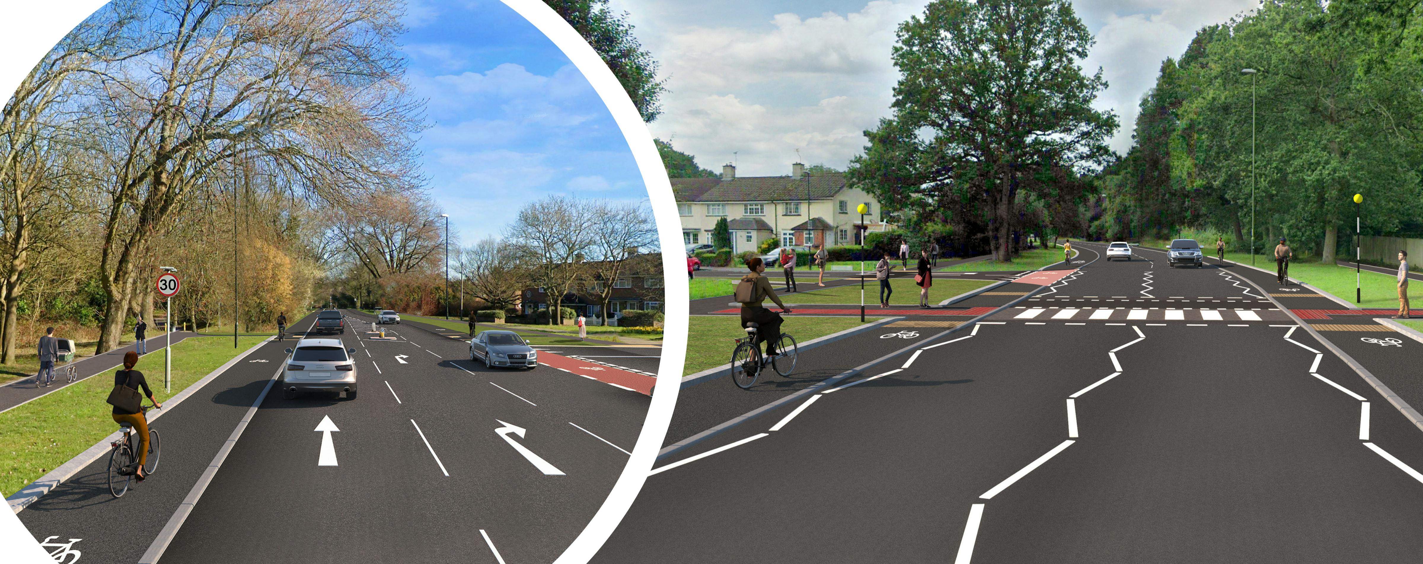
- Widen and improve the existing off-road cycle track between Northgate Avenue and Woodfield Road;
- Provide a new parallel crossing on Woodfield Road, with dedicated space for pedestrians and cyclists, connecting with the off-road cycle path;
- Provide raised tables at junctions on Woolborough Lane (south of the subway) to encourage lower vehicle speeds and allow cyclists to safely access the new crossing facilities. Cyclists would continue to ride in the carriageway on a very short section whilst parking will be retained only on the residential houses side of the road;
- Potential lighting improvements to the underground subway;
- Provide a new two-way cycle lane on one side of Woolborough Lane (north of the subway) connecting with the existing off-road path leading to Manor Royal. In line with LTN 1/20, the cycle lane would be kerbed, to separate cyclists from the main carriageway;
- Upgrade the off-road path between Woolborough Lane and Manor Royal, with segregated provision for pedestrians and cyclists. Widening of the existing path to achieve LTN1/20 compliance will depend on whether the adjacent land can be acquired to widen the path; and
- Upgrade the existing toucan crossing at Manor Royal by converting to a signalised parallel crossing, which would improve safety for cyclists and pedestrians.
- Provide stepped, kerbed one-way cycle lanes on both sides of the road, by removing some of the existing grass verge. The cycle lanes are in accordance with LTN 1/20 guidance, and will help provide a safer environment for cyclists away from general traffic and pedestrians;
- Convert the existing shared-use path on the western side of Northgate Avenue to a footway, as the current path is substandard;
- Reduce the speed limit on Northgate Avenue from 40mph to 30mph; and
- Upgrade crossing facilities in certain locations, including dedicated parallel crossings for cyclists.
Why is the scheme required?
The West Sussex Transport Plan sets out an ambition to deliver sustainable transport improvements in Crawley, increasing connectivity and improving access to services and employment opportunities, including Gatwick Airport, where over half of staff live in Crawley.
At present, cycling and walking facilities across the town are disconnected and to a poor standard. The road network is also heavily congested. This creates an intimidating environment for cyclists and pedestrians, creating safety concerns and reducing the attractiveness of these modes.
The proposed improvements will help address the above-outlined issues, through the delivery of dedicated and high-quality cycle infrastructure which connects key sites across the town. The route, which extends between Crawley town centre and the Manor Royal Business Park, was featured in the Local Cycling and Walking Infrastructure Plan (LCWIP) for Crawley, and has been identified as a priority for further investment.
The proposals align with the objectives set out in the West Sussex Transport Plan and will support wider initiatives to develop and regenerate Crawley town.
How much will the scheme cost and how is it being funded?
At this early stage of design, a detailed costing exercise has not yet been undertaken. However, in order to be successful, any bid to the Government’s Active Travel Fund would need to demonstrate good Value for Money (VfM), which cycling and walking schemes generally do.
Funding for the scheme will be dependent on a successful bid to the Tranche 4 of the DfT’s Active Travel Fund, which is expected to be announced later this year.
What is being proposed?
The final designs are still under development, and the proposals could change depending on the feedback received throughout the consultation exercise. At a broad level, the scheme is looking to:
Northern Section: Manor Royal Link
Southern Section: Northgate Avenue
What standards are the proposals being designed to?
The project will seek to meet the guidance detailed for local authorities in the Government Local Transport Note 1/20: Cycle Infrastructure Design. Beyond that, the Manual for Streets will also be considered.
When will the scheme be built?
The delivery of the improvements is dependent on a successful bid to the Department for Transport’s Active Travel Fund, which is expected to be announced later this year. If successful in the bid, further work will be undertaken to progress the scheme to the detailed design phase, and a construction delivery programme will be developed.
How will people travelling in cars be impacted?
As part of the scheme, we are proposing to reduce the speed limit on Northgate Avenue from 40mph to 30mph. This means that people in cars will have to travel slightly slower than before.
It is anticipated that the proposed improvements will encourage more people to walk and cycle, facilitating modal shift from private car use. By reducing the number of people travelling by car, the scheme has the potential to reduce congestion along the route.
Will the roads become narrower to allow for the new cycle lanes?
There will be some very minor road narrowing on a small section of Woodfield Road, to allow for the proposed cycle path. Please refer to the Crawley North Feasibility Drawing for further detail.
All other general traffic lanes will be unaffected. This includes Northgate Avenue, where we are proposing to use some of the grass verge to allow for the cycle lanes. This means traffic lanes will stay the same width as they currently are.
How will access to bus stops be affected?
We are not proposing to relocate or remove any of the existing bus stops as part of the proposals, so it is unlikely that buses will be affected.
However, to avoid conflict between bus users and cyclists on Northgate Avenue, some further provision may be required to allow people to safely access bus stops without obstructing the cycle lanes. This will be explored at the detailed design stage, but could include things such as bus stop bypasses, and/or pedestrian crossings through the cycle lanes.
Does the scheme require any land take / is my property at risk?
At this stage it is anticipated that the majority of the construction works can take place within the existing highway boundary or land owned by West Sussex County Council. However, for a number of the proposals to be delivered, some minor land acquisition may be required.
We are looking to widen the off-road path between Woolborough Lane and Manor Royal, and provide with segregated provision for pedestrians and cyclists, in line with LTN 1/20 guidance. To allow us to widen the path, this would require a small section of private land to be taken. All affected landowners would be contacted directly by the project team.
Should the land be unavailable, we would instead look to re-mark and redesign the existing path, maintaining its current width. This means that a short section of the proposals would not be fully LTN 1/20 complaint, as there are some narrow sections along the path.
What are you proposing for the subway under Crawley Avenue?
We are looking to upgrade the existing two-way cycle facility running through the subway, connecting with the cycle lanes on either side.
There is also potential to provide lighting improvements in the subway. This will be explored at the detailed design phase.
Will any trees be impacted?
At this stage of design, we are not proposing to remove any trees, and it is expected that trees will be unaffected by the scheme. However, to provide the cycle lanes on Northgate Avenue, this would require some loss of the existing grass verge. To compensate for this loss, we are proposing tree and shrub planting (and/ or regenerative management) on the open verges at the Northern end of Northgate Avenue.
By ‘regenerative management’, this would help encourage tree growth without active tree-planting, as trees/ shrubs are naturally restocked through the falling and dispersion of seeds from existing trees. Some intervention, such as removing competing plants, may be needed to give natural processes a kickstart.
This will be explored at the detailed design phase, where we will consider opportunities to increase biodiversity.
Will parking be impacted?
The existing double yellow line restrictions on Northgate Avenue are currently under review. Any proposed changes (e.g removal or extension of the existing markings) would be subject to further design development and the outcome of a separate statutory process.
On the short section of Woolborough Lane (south of the subway), we are looking to introduce double yellow line parking restrictions on one side of the road. This would mean the removal of approximately 6 informal on-street parking spaces. This will allow cyclists to safely travel through the area. The parking layby on the opposite side of the road will be unaffected.
How will you minimise disruption while the scheme is being constructed?
A scheme construction plan will be developed once the outcome of the consultation is known. Prior to any construction works taking place, the impact of the works on local people, businesses, road users and the environment will be assessed, and mitigation measures designed.
What are the next steps?
We will carefully consider all comments received during the consultation. Feedback received will be used to inform the detailed design phase and the next steps for the proposal. We will document the process and publish the results in a consultation report.
Subject to the outcome of consultation, West Sussex County Council intends to bid for the DfT’s Active Travel Fund later in the year. If successful, the funding would be used to finalise the proposals and construct the scheme.