
FAQs
- Location of the roundabout moved north of the existing A259
- Two new toucan crossings added
- Left turn exit only from retained section of Yapton Road to the A259
- Removal of the proposed A259 westbound bus lane
- Two new toucan crossings added
- Vehicular access to/ from Crookthorn Lane retained
- Removal of the A259 westbound bus lane and replace with new section of shared path on south-side of the A259
- New A259 eastbound bus lane added
- Two new toucan and pegasus crossings added
- Improved footway provision along Crookthorn Lane
- Roundabout proposal was replaced with realignment of Ferry Road approach
- Replacement of an uncontrolled crossing with a new toucan crossing
- New bus only lanes which would allow buses to bypass general traffic at the junctions and thus improve journey time reliability
- New and safe traffic signal-controlled crossings for pedestrians, cyclists and horse riders.
- Outline design, planning applications and OBC development– the current stage
- OBC submission – late 2023
- OBC approval by DfT (not guaranteed) – spring 2024
- Full design and Full Business Case (FBC) development – 2024
- Tender for construction works – summer/ autumn 2024
- FBC submission – late 2024
- FBC approval by DfT – spring 2025
- Construction starts – summer 2025
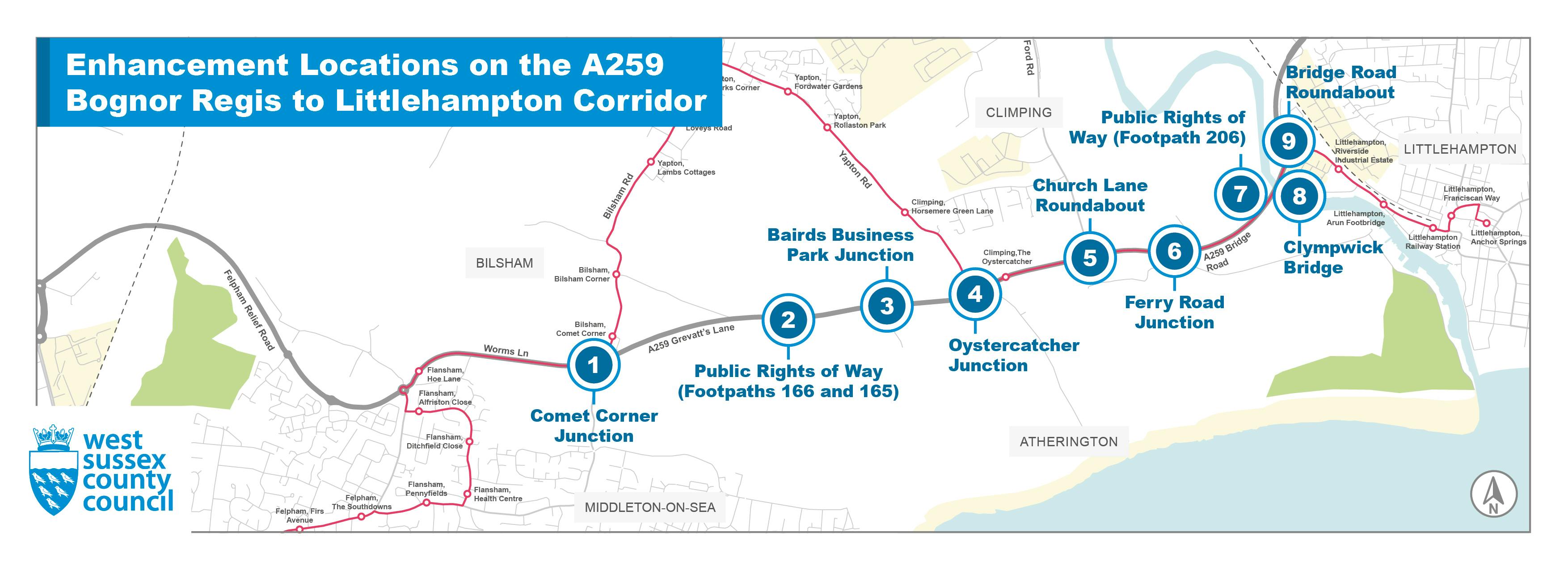
1. Where is the proposed scheme?
The proposed scheme focuses on improving nine locations between the A259/B2132 Yapton Road junction (Comet Corner) and the A259/B2187 Bridge Road (Tesco) roundabout. Please refer to the main page of the consultation website to see details of the nine locations being consulted.
2. Why are we making changes?
Road users are experiencing travel delays along the A259 corridor during peak periods and having road safety concerns about some of its junctions. The proposed scheme aims to relieve congestion on the A259, particularly for those who are joining from the side roads, and to address road safety concerns at the junctions as well as increasing junction capacity to cater for future travel demand.
3. Why doesn’t the proposed scheme cover other junctions in the area?
The proposed scheme initially covered the A259 corridor between the A259/B2259 Flansham Lane and the A259/A284 Wick (Morrison) roundabouts. As the development work progressed, a prioritised list of locations for improvements was identified, concluding in the nine locations presented in the 2023 consultation.
4. Was dualling the A259 considered?
Yes, however this was not found to be required for the A259 corridor between Bognor Regis and Littlehampton based on the traffic modelling assessment work we have undertaken.
5. What are the next steps?
The design has progressed further since the last public consultation in 2021 and we plan to submit it together with an Outline Business Case (or funding bid) to the Department for Transport (DfT) for approval in late 2023. If approved, the design would need to be finalised so that it is ready for construction and the business case updated. Both would have to be approved by the DfT before construction can start, hopefully, in summer 2025.
6. Who is paying for it?
The DfT and West Sussex County Council (WSCC) are funding the current stage of the scheme development. These would need to be reviewed and approved by the DfT before we can proceed to finalising the design and updating the business case.
If the business case is successful, it is anticipated that 85% of funding for the scheme would be provided by the DfT and the remaining 15% would come from local sources such as developer contributions and WSCC’s own funds. At this stage the scheme is estimated to cost around £37.5m (at 2023 prices).
7. What has changed since the last consultation?
Some key changes have been made to the design proposals following feedback from the last consultation and the on-going design refinement. Further details can be found on the main page of the consultation website.
In summary, the key changes were:
1 Comet Corner junction
4 Oystercatcher junction
5 Church Lane roundabout
6 Ferry Road junction
Other smaller changes were proposed at location 2 Public Rights of Way: Footpaths 166 and 165, location 3 Baird’s Business Park junction, location 7 Public Right of Way: Footpath 206, location 8 Clympwick foot and cycle bridge and location 9 Bridge Road (Tesco) roundabout and details can be found on the main page of the consultation website.
The proposal at location 10 Wick (Morrisons) roundabout was removed from the scheme following confirmation to proceed with the construction of the A284 Lyminster bypass.
8. Why do you continue with road building when we are constantly being told we are facing a climate crisis and need to reduce our dependency on the car?
The aims of WSCC’s Area Transport Strategy (please refer to West Sussex Transport Plan 2022 – 2036 for details) are to reduce the need to travel by car, increase use of sustainable modes of transport and upgrade some parts of the strategic road network where it does not meet current needs and/ or those arising from planned development.
As part of this strategy this scheme is intended to be implemented alongside other schemes such as active travel improvements to make active travel a more realistic and attractive option for short distance journeys.
9. I don’t drive, how will the proposed scheme impact me?
The proposed scheme has many benefits for non-car users including:
10. Will you need to remove any trees?
We anticipate some trees would have to be removed to implement the proposed scheme but we expect to replace them.
11. How will wildlife and the environment be protected?
We are working closely with relevant statutory environmental bodies to investigate and assess the impact on the environment, wildlife and ecology, and how to mitigate the impacts as we develop the proposed scheme further.
12. Is the Environmental Impact Assessment (EIA) available?
No, but we will be preparing a full EIA for the work at Oystercatcher junction.
13. Will you be building into undeveloped land?
It is likely that there would be a need to build into undeveloped land at some locations to ensure a compliant design can be achieved. We will work with the affected landowners to achieve a sensible outcome.
14. What provision is made for cyclists to cross at the proposed roundabouts?
Traffic signal controlled (or toucan) crossings would be provided on the main walking and cycling desire lines close to the proposed roundabouts to ensure safe and convenient connections to the National Cycle Network (NCN) Route 2 along the A259 corridor.
15. Why have the speed limits on the A259 been changed?
The current speed limits along the A259 corridor change regularly, meaning drivers may be uncertain what the speed limit may be at any given location. Some of the current speed limits are not appropriate for the look and feel of the road, thus encouraging drivers to travel at inappropriate speeds.
The proposed speed limits were identified based on the road hierarchy (the look/feel of the road, and who is using it), existing speeds and collision patterns. They aim to provide a more consistent speed limit along the corridor while reducing speeds at junctions and crossings where conflicts between vehicles, pedestrians and cyclists may be more frequent.
16. When will construction works start?
We are currently finalising the OBC development and this is an opportunity for you to comment on the design proposals before the OBC it is submitted to the DfT for approval in late 2023.
If approved, we will then move to finalise the design so that it is ready for construction and update the business case accordingly.
It is important to note that no funding has been secured to develop the next stage of the scheme yet. If we are successful, the indicative timetable going forward is:
17. How long will it take to carry out the construction works? Will it be one location at a time?
We won’t have the answers until the contractor(s) have been brought in plan and develop the construction programme. However, it is likely that key junctions such as Comet Corner and Oystercatcher would be constructed separately due to the volume of traffic using the A259.
18. How will you minimise disruptions?
We know the A259 is a busy road and will make sure that the impact of construction works on residents, businesses, road users and the environment is carefully assessed, and mitigation measures designed before starting any construction works. This may include restrictions on working during peak periods, night-time working and use of light and noise mitigation measures.
19. How do I have my say?
We value your feedback. Your opinions are important to us and we would encourage you to make comments through the questionnaire. Closing time and date for responses was midnight on Sunday 23 April 2023.
We will not be considering or responding to any Facebook and Twitter posts as this is not a formal method of engagement.
20. How do I obtain an alternative format?
If you require this information in an alternative format, such as large print or Braille, please contact us on 01243 642105 or via email A259B2L@wsp.com.
If you are deaf or hard of hearing and have an NGT texting app installed on your computer, laptop or smartphone, you can contact WSCC’s Highways contact centre on 018001 01243 642105.
Comet Corner
21. Why can’t the proposed improvements be introduced sooner?
We understand the community’s concerns about road safety at Comet Corner, but there are statutory processes we need to follow and site investigations and assessments to complete when developing a proposal. We will work as quickly as possible so that we can secure the necessary funding to implement the proposal.
22. How will I access the B2132 Yapton Road (south arm)?
Worms Lane to the south of the A259 would be closed to motor traffic, and vehicular access to the B2132 Yapton Road (south arm) would be via the proposed roundabout.
23. What is happening to bus routes?
The current bus routes would remain unchanged, and the proposed bus lane would allow buses on the A259 (from Bognor Regis direction) to bypass the roundabout when heading north towards Yapton village.
24. How would these changes make it safer for pedestrians and cyclists? Will the roundabout be signalised?
Two new traffic signal-controlled (or toucan) crossings were proposed to enable pedestrians and cyclists to safely cross the A259 and B2132 Yapton Road and continue their journeys on NCN 2.
The roundabout would not be signalised.
25. What will happen to the field between Worms Lane and the A259?
There is no plan to develop the field at present.
26. What will the design proposal looks like?
Please visit the documents section of the consultation website to view the technical drawing.
Public Rights of Way (Footpaths 166 and 165)
27. What sort of crossing is proposed?
A pedestrian refuge (or uncontrolled crossing) was proposed to allow crossing of the A259 on foot.
28. What are uncontrolled crossings?
An uncontrolled crossing is an informal crossing which usually includes dropped kerbs, tactile paving and a pedestrian refuge (or traffic island) where there is sufficient road width. It is different to a controlled crossing such as puffin, toucan and pegasus where traffic signals are used to manage traffic or zebra crossings.
29. What will the design proposal looks like?
Please visit the documents section of the consultation website to view the technical drawing.
Baird's Business Park junction
30. What will the design proposal looks like?
Please visit the documents section of the consultation website to view the technical drawing.
Oystercatcher Junction
31. What is happening to the bus routes?
The current bus routes would remain unchanged, and the proposed bus lane would allow buses on the B2233 Yapton Road (from Yapton village) to bypass the roundabout when heading east towards Littlehampton.
32. What would happen to the bus stops?
The eastbound bus stop on the north-side of the A259 (opposite Maidenhead Aquatics Centre) would be relocated slightly to the west of its current position. The northbound bus stop on the south-side of the A259 (just west of Climping Street) would be relocated to the east of the access to/from Maidenhead Aquatics Centre.
33. Where would access to The Oystercatcher Inn and Jaybelle Grange Lodge Park be from?
The current access to the Oystercatcher Pub and Jaybelle Grange Lodge Park to/from the A259 would be retained.
34. How would these changes make it safer for pedestrians and cyclists? Will the roundabout be signalised?
Two new traffic signal-controlled (or toucan) crossings were proposed to enable pedestrians and cyclists to safely cross the A259 and B2233 Yapton Road and continue their journeys on NCN 2.
The roundabout would not be signalised.
35. What are uncontrolled crossings?
An uncontrolled crossing is an informal crossing which usually includes dropped kerbs, tactile paving and a pedestrian refuge (or traffic island) where there is sufficient road width. It is different to a controlled crossing such as puffin, toucan, Pegasus where traffic signals are used to manage traffic or zebra crossings.
36. Why did you not consider locating the proposed roundabout to the west of its current position?
The developer for the land at Climping has already committed to provide an area of their land for the proposed roundabout as part of the development agreement before we started developing this proposal.
37. How would access to my business be affected during construction?
Detailed plans around access to businesses will be fully developed and communicated before the start of construction. Any impact to businesses will be mitigated as much as possible.
38. What will the design proposal looks like?
Please visit the documents section of the consultation website to view the technical drawing.
Church Lane Roundabout
39. Will Crookthorn Lane be closed to motor traffic?
Vehicular access between Crookthorn Lane and the A259 would be maintained via a new T-junction following feedback from the previous consultation in 2021.
40. How would these changes make it safer for pedestrians and cyclists and equestrian users? Will the roundabout be signalised?
A new traffic signal-controlled (or toucan) crossing was proposed to enable pedestrians and cyclists to safely cross the realigned Church Lane and continue their journeys on NCN 2.
A new traffic signal-controlled (or pegasus) crossing was also proposed to the east of the roundabout to enable pedestrians, cyclists and horse riders to safely cross the A259.
The puffin crossing to the west of the relocated roundabout proposed by the land at Climping developer would be changed to a toucan crossing.
A section of the existing Church Lane would be retained for use by pedestrians, cyclists and horse riders. A new footway was also proposed to connect the A259 and the local primary school.
The roundabout would not be signalised.
41. What will happen when the land at Climping development moves forward?
The proposal was a modification of the approved developer’s roundabout layout and will be constructed if we secure the necessary agreements from the developer, approvals from Arun District Council and funding from the DfT. If not, the developer will proceed to construct their approved layout.
42. What is happening to the bus routes?
The current bus routes would remain unchanged, and the proposed bus lane on the A259 would allow the buses to reach the roundabout unimpeded when heading east towards Littlehampton.
43. What will the design proposal looks like?
Please visit the documents section of the consultation website to view the technical drawing.
Ferry Road Junction
44. What happened to the proposed roundabout?
The proposed roundabout has been dropped following feedback from the previous consultation in 2021 and further traffic modelling assessment work. Instead, a realignment of Ferry Road approach to the A259 and new traffic islands were proposed to provide safer right turns into the side roads.
45. How would the proposal make it safer for pedestrians and cyclists?
A new traffic signal-controlled (toucan) crossing was proposed to replace the uncontrolled crossing. This would enable pedestrians and cyclists to safely cross the A259 and continue their journeys on NCN 2.
46. What will the design proposal looks like?
Please visit the documents section of the consultation website to view the technical drawing.
Public Rights of Way (Footpath 206)
47. Will the proposed ramp be suitable for those using wheelchairs and scooters, etc.?
The proposed ramp was designed according to the latest design guidance and would be suitable for use by those on wheelchairs and scooters.
48. What will the design proposal looks like?
Please visit the documents section of the consultation website to view the technical drawing.
Clympwick Foot and Cycle Bridge
49. What is the proposal?
It is a new bridge, parallel to the existing A259 Clympwick Bridge that would provide pedestrians and cyclists with a dedicated and safe facility to cross the River Arun.
50. What is a cable stayed bridge?
A cable stayed bridge is where the weight of the deck is supported by cables attached to vertical support towers. The visualisations give a presentation of the proposed bridge.
51. Why can’t you widen the existing bridge to cater for both walking and cycling?
It is not possible to widen the existing bridge due to structural constraints and there is insufficient room to provide a shared path for walking and cycling that complies with the latest design guidance.
52. What will the design proposal looks like?
Please visit the documents section of the consultation website to view the visualisations.
Bridge Road (Tesco) Roundabout
53. How would the proposal make it safer for pedestrians and cyclists? Will the roundabout be signalised?
Two new traffic signal-controlled (or toucan) crossings were proposed to enable pedestrians and cyclists to safely cross the A259 northern arm and Broad Piece. The shared use path would also be provided to ensure safe passage to and from the proposed Clympwick foot and cycle bridge and Tesco and other retail outlets in the area.
The roundabout would not be signalised.
54. Why is there a filter lane?
The left-turn filter lane on the B2187 Bridge Road to the A259 (east to west) would allow vehicles to bypass the roundabout when heading towards Bognor Regis direction, thus reducing potential delays at the roundabout.
55. What will the design proposal looks like?
Please visit the documents section of the consultation website to view the technical drawing.
Wick (Morrisons) Roundabout
56. Why is the proposal at Wick (Morrisons) roundabout not being taken forward?
The proposal has been removed from the proposed scheme following confirmation to proceed with the construction of the A284 Lyminster bypass.