
FAQs
- Land along the frontages of various redevelopment sites along the A259.
- Land along the frontage of the Ham Village Green (Shoreham skatepark) and Kingston Beach Village Green. This may require suitable replacement Village Green land in the local vicinity to be identified subject to further consultation with the local community.
- Land along the north side of the A259 between Grange Road, Station Road and Colebrook Road (Southwick), and between West St and William St (Fishersgate).
- Additional small pockets of land owned by third party landowners.
Why is the scheme required?
The West Sussex Transport Plan 2022-2036 (opens in new window) sets out an ambition to deliver sustainable transport improvements across the county, increasing connectivity and improving access to services and employment opportunities. Adur & Worthing Councils have also developed a Local Cycling & Walking Infrastructure Plan (LCWIP) that aims to improve the cycle network across the area.
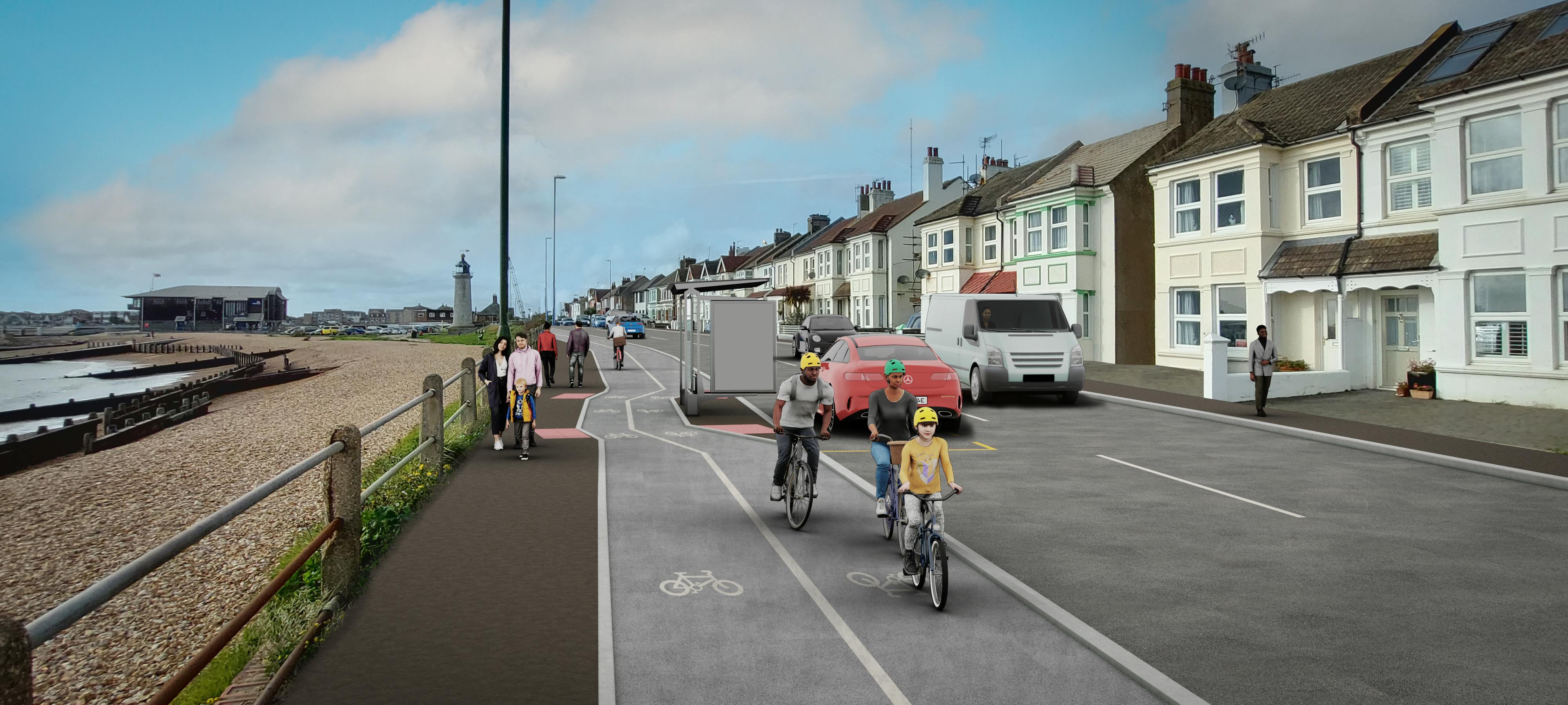
The scheme would provide a safer, more desirable, and direct route for the National Cycle Network Route 2 (NCN2), along the A259, between Adur Ferry Bridge and the county boundary with Brighton & Hove. The cycle route would provide a safe space for cycling that is off the carriageway, either as two-way cycle lanes separated from the road and footway, or shared space with pedestrians in locations where space is limited.
The Shoreham Harbour area is also part of a regeneration project that includes mixed use redevelopment on the Western Harbour Arm, found to the south of the A259. It is therefore important to develop high quality cycle infrastructure that could serve these developments as well as the existing communities in the area.
How much will the scheme cost and how is it being funded?
At this early stage of design, a detailed costing exercise has not yet been undertaken, however we expect the scheme costs to be in line with similar cycle schemes being delivered around the country. However, to be successful, the scheme would need to demonstrate good value for money, and the scheme is subject to the development of a business case.
An external funding stream would be used to deliver the proposals. This includes developer contributions and central Government grants that are intended for active travel schemes.
Congestion is more of an issue in the area, why are you not improving this first?
The West Sussex Transport Plan 2022-2036 (opens in new window) identified the need for improvements to highways, public transport and active travel facilities to tackle congestion. The County Council and organisations such as National Highways are developing a range of improvements so that they can be delivered as funding opportunities arise.
By providing a safe space for cycling that is off the carriageway, we aim to encourage more people to cycle between Shoreham and Brighton, particularly those people that are less confident cyclists. The route would provide connections between new and existing communities and a number of key destinations within the area, including Shoreham town centre, Brighton & Hove, railway stations, education facilities, retail businesses and employment areas. The scheme would therefore make it easier for people to walk or cycle to these destinations rather than using their vehicles.
Are these options LTN 1/20 compliant?
The Government’s Local Transport Note (LTN) 1/20 (opens in new window) provides guidance and good practice to local authorities for the design of high-quality cycle infrastructure.
The guidance has informed our proposals for the route between Shoreham and Brighton & Hove, and as such we have proposed two-way cycle lanes that are separated from both the carriageway and footway. However, there are small sections where the amount of available highway space is limited, so to maintain space for vehicles using the A259, we have proposed shared use paths.
We believe this scheme best balances the needs of all roads users but would like to receive feedback to help develop the scheme.
Will the cycle lanes continue past the county boundary?
Brighton & Hove City Council is considering a connection along the A259 to the wider cycle network in the city as part of its Local Cycling and Walking Infrastructure Plan, where the A259 is a priority strategic route.
I live along one of the proposed routes. Will I still be able to access my driveway?
Yes, existing access to driveways will be maintained via dropped kerbs.
Are you considering any bus priority measures/improvements to services?
As part of the scheme, we are proposing to slightly relocate some bus stops to accommodate the proposals and upgrade the facilities at others (such as installing bus shelters). The positioning of some bus stops is subject to the redevelopment plans in the area. The scheme also provides the opportunity to consider the provision of traffic signal technology to provide greater priority for any late running buses along this section of the A259.
The County Council is also developing other plans for bus service improvements and in December 2021 we published our Bus Service Improvement Plan (BSIP). This set out the ways in which we can improve bus services within West Sussex and increase the number of journeys made on buses after a decline during the Covid-19 pandemic.
The Department for Transport has provisionally awarded West Sussex County Council up to £17.4 million of this BSIP funding. We are now looking to see how we can best spend this money on delivering the key elements of the plan.
I can’t attend the in-person events but I want to speak to a member of the project team, what should I do?
You can either email the team at STIPActivetravel@westsussex.gov.uk or you can telephone 01243 642105. If you are deaf and have the NGT app installed on your PC, laptop or mobile phone, you can contact us on 18001 01243 642105
We are also holding an in-person event for the Lancing and Sompting scheme (opens in new window) on Wednesday 15 February at the Sir Robert Woodard Academy, between 4pm and 8pm, and an online event on Wednesday 22 February between 7pm and 8pm on Microsoft Teams (to register, please email STIPActivetravel@westsussex.gov.uk). Although primarily focused on the proposals within Lancing and Sompting, members of the team would be happy to discuss and answer any questions on the A259 Shoreham proposals at these events.
If the scheme is to go ahead, will there be road closures during construction?
Before any construction on the scheme starts, a Construction Management Plan will be published to minimise the impact on the local community as much as possible. This will detail any temporary road closures, along with changes to access for pedestrians and cyclists as well as diversion routes.
Does the scheme require any land take / is my property at risk?
At this stage it is anticipated that the majority of the construction works can take place within the existing highway boundary or on land owned by West Sussex County Council. However, some non-highway land would be required, including at the following locations:
We are in dialogue with the impacted landowners to develop these aspects of the proposals.
UPDATE 19/01/23: We have made an update to Map 2, adding a text box to clarify the plans for a strip of land along the northern boundary of Kingston Beach. The technical drawings and FAQ note above already contained this information and have not been updated.
When would you expect the scheme to be built?
Future progression of the scheme will be informed by the outcomes of this consultation. Further design and consultation would be needed before any scheme could be constructed. Construction would be subject to the release of redevelopment land, a business case, all relevant statutory processes (e.g. planning) and securing central Government funding for scheme delivery. It is therefore not possible to confirm a delivery timescale at this stage.
What are the next steps?
We will carefully consider all comments received during the consultation. Feedback received will be used to inform the detailed design phase and the next steps for the proposal and will help to build the case for funding the scheme. We will document the process and publish the results in a consultation report.